
IOT BASED POTHOLE DETECTION SYSTEM
Project report submitted in partial fulfillment of the requirement
for the degree of
Bachelor of Technology
In
Computer Science and Engineering
By
SanchiThareja (151272)
Ayushi Jayaswal (151317)
Under the Supervision of
Dr. Hemraj Saini
To
Department of Computer Science & Engineering and Information Technology
Jaypee University of Information Technology Waknaghat
Solan-173234,Himachal Pradesh
CERTIFICATE
Candidate’s Declaration
We hereby declare that the work presented in this report entitled IoTBased Pothole
Detection System in partial fulfillment of the requirements for the award of the degree of
Bachelor of Technology in ComputerScience and Engineering submitted in the
department of Computer Science & Engineering and InformationTechnology, Jaypee
University of Information Technology, Waknaghat is an authentic record of our own work
carried out over a period from August 2018 to May 2019 under the supervision of Dr.
Hemraj Saini, Assistant Professor (Senior Grade), Computer Science & Engineering and
Information Technology.
The matter embodied in the report has not been submitted for the award of any other
degree or diploma.
Ayushi Jayaswal, 151317 SanchiThareja, 151272
This is to certify that the above statement made by the candidate is true to the best of my
knowledge.
Dr. Hemraj Saini
Assistant Professor (Senior Grade)
Computer Science & Engineering and Information Technology
Dated:
i
ACKNOWLEDGEMENT
We have taken efforts in this project. However, it would not have been possible without
the kind support and help of many individuals and organizations. We would like to extend
our sincere thanks to all of them.
We are highly indebted to Dr. Hemraj Saini for their guidance and constant supervision
as well as for providing necessary information regarding the project and also for their
support in completing the project.
We would like to express our gratitude towards our parents and Jaypee University of
Information Technology for their kind co-operation and encouragement which helped us
in completion of this project.
Our thanks and appreciations also go to our colleague in developing the project and
people who have willingly helped us out with their abilities.
ii

TABLE OF CONTENTS
CERTIFICATE…………………………………………………………..i
ACKNOWLEDGEMENT………………………………………………ii
TABLE OF CONTENTS……………………………………………….iii
LIST OF FIGURES……………..………………………………………iv
LIST OF TABLES………………………….…………………………....v
ABSTRACT……………………………………………………………...vi
1. Chapter-1 INTRODUCTION
1.1. Introduction……………………………………………………………………1
1.2. Problem Statement………………………………..…………………………...3
1.3 Challenges Involved……………………………………………………………4
1.4 Objectives………………………………………………………………………4
1.5 Methodology……………………………………………………………………5
2. Chapter-2 LITERATURE SURVEY………….……………………...7
3. Chapter-3 SYSTEM DEVELOPMENT
3.1. Hardware Requirements..………………………………………………........ 18
3.2. Software Requirements…………………………...…………………………..27
3.3. Design& Diagrams……………………………….…………………………..30
3.4. Algorithm….………………………………………..…………………………31
3.5. Computational.………………………………………...………………………34
3.6.Experimental…………………………………………….…………………….35
4. Chapter-4 PERFORMANCE ANALYSIS………….………………..37
5. Chapter-5 CONCLUSIONS
5.1. Conclusions…………………………………………………………………....39
5.2. Future Scope…………………………………………………………………...39
REFERENCES……………………..……………………………………41
iii
Figure Title Page

Number
1.1 A pothole 3
2.1 Road Audit Application 15
2.2 Spothole Application 16
2.3 Pothole Finder Application 17
2.4 Pothole Marker App 17
3.1 No pothole & pothole case 18
3.2 Ultrasonic Sensors 19
3.3 Accelerometer 21
3.4 Raspberry Pi Board 24
3.5 Arduino Uno 24
3.6 Arduino IDE 28
3.7 Arduino Sketch 29
3.8 Python IDLE 29
3.9 Block Diagram Data Collection 30
3.10 Sequence Diagram 30
3.11 Database Connection Diagram 31
3.12 Ultrasonic Module Algorithm 34
3.13 State-wise total accidents 36
3.14 Share of vehicle types in accidents 2017 36
LIST OF FIGURES
iv
LIST OF TABLES
Table Title Page Number
2.1 Comparing strategy approaches 8
2.2 Comparison btw communication
approaches
10
2.3 Comparison of existing products 14
3.1 Difference between microprocessor and
microcontroller
27
3.2 Instrument Specifications 35
3.3 Road accidents in 2016-17 35

4.1 Whatsapp Notification 38
4.2 Alert on Whatsapp 38
v
ABSTRACT
The significance of the road framework for the general public could be contrasted as the
significance of veins for people. India is a developing nation which does not have the
appropriate support of the street, over 95% of the general population utilizes road
transportation. Because of this pinnacle utilization of street transports, there are numerous
potential outcomes of potholes on streets which prompt accidents. Other significant
purposes behind such accidents are the head on head crashes. This task means to create a
Pothole Detection and Notification System. The principal segments of the undertaking are
the Accelerometer, Ultrasonic Sensor, Wi-Fi Module, GSM, with Arduino Uno, and the
Raspberry Pi Board. This task would be given to government street temporary workers to
redress the potholes and keep away from mischance and help in rush hour gridlock
examination. Likewise, our point is to make security frameworks moderate for each
vehicle in the nation.
Keywords: Arduino; ultrasonic sensor; accelerometer; GPS; Bluetooth; IoT.
vi
Chapter-1
INTRODUCTION
1.1 Introduction
Internet of Things (IoT) is the system of devices, for example, electrical machines,
physical gadgets and different things installed with sensors and actuators that empower
the articles to set up an association with various frameworks which thusly trades
information. Everything is exclusively distinguished through its distinctive implanted
registering however it is worked in the current foundation of the Internet.
IoT detected the items and remotely constrained by getting to over the current framework
of the system, making more open doors for a different mix of this present reality into the
PC based savvy frameworks, and results in improved precision, monetary advantages and
proficiency to decreased human inclusions. At the point when the expansion is finished
with the actuators and sensors, it encompasses robotization in different fields, for
example, keen power plants, astute transportation, shrewd homes, savvy matrices and
brilliant urban areas. A developing nation without a doubt needs a system of solid and
travelable streets to fulfill the need of regularly expanding traffic. Nonetheless, numerous
nations, for example,Sri Lanka, have streets dabbed with potholes, yet no street observing
framework to watch the street condition. Lately,the harm to the surface because of
mileage moves toward becoming extravagant to fix.
There are a few focal points of having a successful street surface observing framework,
however they are very costly. Such a framework can distinguish issue zones early and the
pertinent experts can be cautioned in time to take preventive measures. Preventive
measures continuously set aside extra cash. Plus, the examining of the information
gathered through an observing framework prompts a superiorcomprehension of the street
weakening procedure, which will prove to be useful when new street systems are being
arranged. In spite of the fact that, over the long haul, an observing framework enables the
expense of street support to exceed its underlying speculation cost, creating nations
dependably search for a minimal effort mechanical assembly to tackle their concern.The
suitability of this checking framework relies upon its capacity to robotize the way toward
1
recognizing the state of the street surface (for example potholes) by breaking down the
increasing speed information close by. In this paper, we present anew and straightforward
procedure for mechanizing the pothole identification process.
The applications for web associated gadgets applications are broad. There are plenty of
classifications which have been proposed, the greater part of which are
Infrastructure administration: farming, ecological observing, fabricating, vitality
the executives, building and home mechanization, metropolitan scale
organizations
Consumer application: smart houses and homes
Enterprise: media
Other fields: transportation, medicinal services, restorative
Each field finds an application on IoT in view of capacity to organize implanted gadgets
with restricted assets. Every such framework gathers information and data from the
normal biological system in detecting the extent and discovers the applications in the
fields of urban arranging and ecological detecting.Pothole recognition has been the point
of much research before and new courses for dodging different kinds of impediments in a
different environment have been tested upon. Be that as it may, the spotlight has been
generally on impediment shirking via self-ruling operators and that excessively was, for
the most part, restricted, making it impossible to expelling obstructions. These would, in
general, make the recognition instrument exceptionally framework particular and very
little reasonable for general purposes. The way that a gadget isn't completely independent
does not imply that it can extricate no advantage from a deterrent location framework.
Actually, regardless of whether the client has satisfactory power over a gadget, he/she
may at present profit by such a discovery instrument. Initially, a human client, for
example, a man pushing an infant carriage or a basic supply truck may not continuously
be sufficiently mindful to distinguish each deterrent in transit and hazard the
inconvenience of waking a dozing child or scrambling the basic supply things
everywhere. Likewise, clients who utilize wheelchairs may need such a framework
particularly on the off chance that they confront trouble moving their head and watch out
for low or discouraged impediments physically. The framework can likewise be useful to
manual products change trucks in vast stores and so forth where an extensive measure of
products heaped up for brisk dislodging does not experience the problem of unpredictable
2

attaching, along these lines risk falling if the wheel of the truck is shocked by a pothole or
something like that.
Figure 1.1 A pothole
Presently however, much work has been improved the situation identifying different sorts
of projecting snags, discouraged obstruction identification has been fairly ignored since it
is normally less clear. Techniques that have been gone for were generally mechanical
(anticipated parts from the vehicle that identifies potholes simply after it contacts
them/falls in them) or dependent on picture preparing. These either signify the expense or
make the physical gadget superfluous cumbersome and clumsy. This undertaking was
therefore adapted to address the issues of the clients who have moving control over their
vehicles yet may discover it exceedingly helpful to have a basic impediment, and
particularly potholes, recognition gadget. In view of that, examine was directed to
discover the correct degree of necessities of the clients. It was discovered that all
wheelchair seats clients were firmly against self-ruling shirking by their vehicle. With the
proposed system an attempt has been made to endorse drivers to ward off the accidents
caused due to potholes and precarious slopes. In case of emergency help and accident
cases, sending the real-time location to the registered number can save lives.
1.2 Problem Statement
The key road anomaly, i.e. potholes has been causing mayhem for the commute. It can be
caused due to internal factors like pavement erosion by water seeping under it, due to a
change in the climate like heavy rainfall, or external factors such as poor construction
management and heavy traffic. Other factors for this include mole rats tunneling under
the road and mechanical damage. Potholes are inflicting major effects such as engine
damage, traffic coagulations, vehicle damage and accidents which are leading to deaths.
Potholes have had huge economic impacts and are causing troubles to our daily routines
as well. Few of the approaches to fix the potholes include regular inspection of roads,
3
establishing hotlines, creating awareness among the public and requesting them to inform
the local authorities and implementation of modern technologies such as automated
systems.
The detection of potholes using automated systems is highly studied about now. The
identification and fixing of the problem may reduce the fuel consumption, wear-tear, and
maintenance cost of vehicles. Automation of systems not only reduces the human labor
that goes into the detection of potholes but also saves a lot of time and are a lot more
efficient. The paper focuses on the current challenges with the existing technology and
how the proposed idea would be a boon to solve the present-day problems with road
commute due to disturbances like potholes using automated systems overcoming the
negatives of the already existing work
1.3 Challenges Involved
.• Client gadget must have the capacity to detect the pothole. It will be an additional
favourable position on the chance that it can describe the pothole telling the seriousness.
• Placement of sensor focuses is a critical factor. It ought to be so that the information
ought to be effectively recorded.
• Communication between sensor point and customer gadget can have numerous issues
which ought to be settled. A portion of the issues that correspondence can confront is an
obstruction, Low throughput because of the area of sensors, end to end reliability.
1.4 Objectives
With the increase in world’s population, there has been increasing load on the
infrastructure. Streets have been overflowed with the vehicular activity. It has turned out
to be progressively hard to deal with this activity. This is the main inspiration driving
making a vehicle sufficiently insightful to help the driver in different perspectives. One of
the increasing problems the roads are facing is worsened road conditions. In view of
numerous reasons like downpours, oil slicks, street mishaps or inescapable wear and tear
make the street hard to drive upon. Unforeseen obstacles on street may cause more
mischances. Likewise in view of the terrible street conditions, fuel utilization of the
vehicle expands; causing wastage of valuable fuel. Due to these reasons, it is imperative
4
to get the data of such terrible street conditions. Collect this data and convey it to different
vehicles, which thus, can caution the driver. As a matter of first importance, there are
different strategies to get the data about the street conditions. At that point, the data must
be passed on in the way which can be comprehended and utilized by the driver. We in this
venture endeavor to plan and assemble such a framework. In this system, the access point
collects the information about the potholes in the region of a remote passage and cautions
the driver about it through a buzzer. Here 'region' is a client characterized term. Ideally,
the region is every rout till the next access point.
1.5 Methodology
There are four guideline parts to the data collection setup; The PDA, sensor bit, data
logging terminal, and a human manager. As the vehicle comes the road the sensor
assembles the vertical (Y) speeding up, and level (X) increasing speed of the vehicle, on
numerous occasions every second; the sensor accumulates 100 models for consistently.
Regardless of the way that the sensor gets both Y and X. reviving, only the Y expanding
speed is used for this investigate in light of the way that the vertical advancement of the
vehicle can be clearly mapped to the improvement right when the vehicle falls into a
pothole (Fig 3). The level piece of the expanding speed also changes when a vehicle goes
over a pothole, anyway we limit the degree of this examination to dismembering so to
speak the vertical section of the animating. For all of these precedents, the PDA
introduces the present GPS bearings to the PC. So GPS encourages for every model will
be recorded in the data archive.
Despite that, for exploratory purposes, manual pothole recording ought to be finished.
Right when the human customer feels that the vehicle is going over a pothole, he
responds by giving a banner to the data logging terminal. This data is moreover recorded
with the accelerometer readings and the GPS sorts out. Subsequently, it will in general be
checked whether the recognizable proof computation truly separates a pothole close that
region.
Choosing a sifting procedure
5
The main period of the separating procedure is to evacuate the clamor brought about by
the motor vibration and poor stun engrossing nature of the vehicle from the signs
recorded amid perception. To separate between the vibrations brought about by the
potholes and the clamor, we accepted that the vibrations are of low recurrence and the
commotion is of higher frequencies. Along these lines, by utilizing a low-pass channel,
we would most likely refine the flag.
6
Chapter-2
LITERATURE SURVEY
2.1 Approach
The framework is ordered into three subsystems which are Sensing, Localization and
Communication. The three subsystems work autonomous of one another, yet have one
basic base point they spin on is information. Fundamentally, Sensing framework creates
the information, Communication gathers, co-ordinates and disseminates the information,
and Localization utilizes the information and produces data for the driver.
2.1.1 Sensing Subsystem
This system uses 'Accelerometer' to distinguish potholes and a change in the keeping
away from point. We use the Ultrasonic feeler which is a apparatus used to calculate
the sliding doors to an inquest by using resonance rays. It allocates relinquish by
transfer a echo signal at a precise replicate and alteration in for that sound signal to
rebound back.
Vision-based strategy:
This scheme uses 'Camera' seeing that a feeler to gaze at the highway in favour of
every potholes. The camera gets photos ceaselessly. These photos are associated with
picture taking care of counts like edge area. This requires an impressive proportion of
getting ready occasion and influence. Close at hand are various structures approach
probable. However in meantime, the rejoinder instance of the actions obligatory like
windowing difficulty for image getting all set figure is as so far broad. This practice
has one good quality spot over the erstwhile is, it can tell apart a hole without
experience it for example motor vehicle does not by several widen of the head need to
understanding the depression to categorize it. Depiction of a pothole ought to be
conceivable dependent on bulk of dip. Various other methods for obstacle area are
RADAR nevertheless they have slight use in dip acknowledgment. Vision-based
detecting is additionally generally utilized in different computerization applications
and mechanical technology. Applications incorporate confinement, mapping,
direction, object acknowledgment, or impediment recognizable proof.
Vibration based strategy:
7

This system uses 'Accelerometer' to recognize potholes. This is a tool that gauge
indicate precise outer surface control on feeler. For instance if the mechanism is
immobile, it willpower display some scrutinizing identifying with earth gravitational
supremacy. An accelerometer declining uncomplicatedly in space will exhibit nil
scrutinizing. The planning of the accelerometer is customarily extremely undeviating.
The machine is mostly used to estimate tremor or partiality. It is normally used in
iTouch in addition to a combine of cameras to make out proclivity and transform the
face of outlook of the prove.
Table 2.1: Comparing both approaches
Here we accept the latter practice that is Vibrations based tactic given the short feedback
point, usage moment and sustain price of the contraption.
2.1.2 Communication Subsystem
This subsystem is in charge of detecting the information i.e. the scope and longitude of
the area of the pothole. A GPS gadget decides the area of a vehicle to which it is
appended. This position will be recorded at standard interims. The pothole's area
information can be transmitted to an information base which enables the benefit's area to
be shown while breaking down the track later. This communication subsystem is
responsible for detection pothole location and conveying it.
8
Whole Wi-Fi inclusion:
This is additionally a famous methodology in a few proposed frameworks which are
security situated e.g. Vehicle Infrastructure Integration. In this methodology, passages are
sent out and about so every now and again that vehicle will never be out of system
inclusion. Or possibly Access focuses are planted at incessant interims where they are
required for instance clumsy regions, hazardous turns. In our methodology, we can put
passage for the greatest inclusion or where the street conditions are particularly terrible.
Passageway continues broadcasting the situation of the pothole in its range. Also, vehicles
can give prompt input of new potholes or non-existent potholes which are recommended
by the Access point. Here passage can likewise help vehicle in finding the area of the
pothole. Be that as it may, this methodology requires an expansive introductory
speculation for conveying the passages.
Open transport as an Access point:
In this methodology we utilize Public transport, for example, Busses for city or town
inclusion or ST transports for roadway inclusion. In this methodology Access point itself
is moving. This sort of approach has been recently utilized for gathering information from
booths in provincial areas. Alternately in our methodology, we are utilizing open transport
for dispersing the information to different vehicles. For this situation passage itself is
moving, subsequently, we can give a Sensor gadget to the passageway. This will spare per
private vehicle cost of gadget by exempting them from detecting application. Open
transport vehicle will detect the potholes on its way and communicating data about that to
alternate vehicles cruising by. Vehicles outfitted with the customer gadget can get this
information. Be that as it may, this methodology has a few issues. The inclusion isn't
tremendous. as data about just those potholes are accessible which are secured by open
transport and there might be streets on which the transports don't drive. Additionally,
transport just has data about its own course which might possibly be valuable for the
vehicle as Vehicle can take anyway. So vehicle must have some path by which they know
which information will be helpful for them.
Hotspot approach:
Hotspots are customarily known to give Internet associations at open spots like cafés.
For those situations, it is utilized to give some support of the general population. The
equivalent approach is utilized can be utilized in our undertaking as pursues. In this
9

methodology Access, focuses are sent at chosen places where vehicle focus is more
similar to Traffic signals, petroleum siphons. This system can provide the complete
road reflection. In the intellect, it know how to find data as of several car have the
client mechanism. Subsequently where on earth the vehicle can depart the motor
vehicle can form data for that street It be able to propose the chance to point looking
at analysis without truly executing an Access point on those roads. This approach can
even be associated locally for some exacting district; which have more than ever high
combination of potholes. In any case, this approach in like manner powers a couple of
difficulties.As passageway is absent at the genuine place, the vehicle needs to locate
its own way; hence restriction is troublesome.
Table2.2: Comparison between communication approaches
For the correspondence subsystem, we pick the third Hotspot approach due to its
inclusion and adaptability. But since of this restriction winds up troublesome.
2.1.3 Localization Subsystem
Confinement System utilizes the information given by Access Point to discover the
pothole's area and in the long run break down territories. After the sensor information is
gotten, it is prepared it is sent to the cloud and put away. Scope and longitude of pothole
area Data are brought from the cloud to plot the area. We imagine the pothole discovery
framework as a foundation benefit later on, utilized by different applications.
10
GPS (Global situating framework):
As we as a whole realize this is an exceptionally prevalent area discovering framework. It
is additionally the first and till as of late the main worldwide and completely practical
area discovering system. It depends on the correspondence with 24 satellite circling
around the earth. It fills in as pursues. These 24 satellites are spinning around the earth in
6 unique ways. Hypothetically at any point, you require a point to point association with
somewhere around 4 satellites to get your position. It fundamentally takes 4 estimations
to decide 4 parameters x,y,z,t. And after that speaks to in the frame comprehended by the
client like scope/longitude. In genuine setting, It may even require fewer satellites in the
event that one of the parameters is known. For instance, dispatches cruising in the ocean
know their elevation to be zero. Additionally more the satellites you can associate with
additional exact area you will get. GPS areas can get as exact as up to 15meters. So in our
framework information about potholes is put away as far as x,y,z parameter. Likewise, a
long length of an awful street perhaps spared as a [(x1,y1,z1),(x2,y2,z2)] which show the
begin furthermore, end of an awful street. This information can be utilized by vehicles
straightforwardly. As when they get the information from the passage the spots where
potholes are there can be indicated particularly on the GPS delineate. As indicated by the
seriousness of the pothole or street it tends to appear with distinctive brilliance.
Additionally, when the vehicle detects another pothole it stores the relating GPS
parameters in its neighborhood and gives as a criticism to prompt the access point.
Yet, there are a few issue with this innovation. As a matter of first importance it is
exceedingly costly. For keeping up as well as even the GPS collector is exorbitant.
Another issue with GPS It needs an unmistakable perspective of circling satellite; so it
doesn't work legitimately in-entryways what's more, fundamentally in the recently
shaping urban ravines where it is required the most. Likewise, it has a high operational
expense on the off chance that it is made to work progressively, as it needs to refresh its
area at continuous.
2.2 Literature Survey
2.2.1 Wolverine: Traffic & Road circumstance inference using Smartphone Sensors (
IEEE 2012)
Creators:
11
Ravi Bhaoraskar, Nagamanoj ankadhara ,Bhaskarana Ramana ,Purushottama Kulkaarni
Favorable circumstances:
1) Bring into play of a bring collectively server. Weights
2) Some filter frameworks and pushed AI techniques are to be associated with energize
upgrading. The planned arrangement use sensors at hand resting on cellular phones. The
manuscript concentrate to perk up the figure focus to using GPS, acceleroometer, and
maganetometer feeler reading for enlargement and street situation identifiable attestation.
2.2.2 Using a Mobile feeler system for street surface monitor: Pothole Patrol
Creators:
Jakoab Eriksson, Levwis Giraod, Brit Huill, Rain Newton, Samauel Mudden,
HariBalakrishnan
Favorable circumstances:
1) A unswerving AI come up to, manuscript illustrate that can distinguish potholes and
further offensive street surface peculiarity from accelerometer facts.
Disadvantages:
1) Position of accelerometers inside the vehicle may influence the nature of the flag. This
paper explores a utilization of portable detecting: identifying and revealing the surface
states of streets. This system, uses the taking an interest vehicles, gathering information
from vibration and GPS sensors, and preparing the information to evaluate street surface
conditions by means of cautious determination of preparing information and flag
highlights.
2.2.3 Road Condition Detection Using Smartphone Sensors: A Survey
Authors:
GunjanChugh, Divya Bansal and Sanjeev Sofa
12
Advantages:
The area of strange street condition can be identified and spared in open source activity
server farm later on.
Disadvantages:
1) Continuous Internet is required.
2) Data ought to be accumulated before applying. The purposes behind broadening
research in this field are –
It will guarantee wellbeing and solace to different street clients
Smooth streets will prompt less vehicle harm and government investment.
The accessibility of ease sensors in Smartphones
The quick increment in the rate of cell phone clients.
In this way, it is objective of the task to create framework which can identify street
conditions utilizing minimal effort sensors present in cell phone.
2.2.4 Road Conditions Detection Using Arduino Based Sensing Module and
Smartphone
Authors:
Syuan-Yi Chen, Annie Shih and Chun-Yi Hsiao
Advantages:
1) The vehicle can get close-by street conditions data effectively.
2) Traffic administration
3) Road mischance aversion
Disadvantages:
1) Continuous web is needed.
2)Sensing module ought to be mounted remotely The point of the undertaking is to create
a street condition identification device(RCDD), which comprises of an Arduino based
detecting module and a UI on android cell phone. It is structured and actualized for
vehicles. The Arduino based detecting module is intended to identify the street conditions
continuously and send the outcome with crude information to the cell phone. The cell
phone gets the information from detecting module, the planned Android UI application
will check the situation with anomalous street condition on Google Maps utilizing the
GPS of cell phone. Subsequently, the vehicle can acquire street conditions data by means
13

of the information shared by adjacent vehicles continuously. As per the guide, the drives
can change their driving examples to enhance driving security, solace and proficiency
2.2.5 Real Time Pothole Detection utilizing Android Smartphones with
Accelerometers(IEEE 2011)
Authors:-
ArtisMednis , Girts Strazdins , ReinholdsZviedris , GeorgijsKanonirs , Leo Selavo
Advantages:
1) 90% of genuine information is utilized.
2) Pothole recognition calculations for organization on gadgets with restricted
equipment/programming assets
Disadvantages:
1) 7% pothole groups were not identified by any of utilized calculations.
2) When the speed of the vehicle is low then the potholes in their will not be identified for
guaranteeing street condition and surface quality, it ought to be checked persistently and
fixed as fundamental. Different ease sensors can be utilized for accumulation of such
information. The paper is portraying a versatile detecting framework for street condition
location utilizing android OS based advanced mobile phones.
Table 2.3: Comparison table of existing products
14
Existing online applications and their features –
Road Quality Audit
o Record from android app
o Inaccurate GPS reviews
15

Fig 2.1: Road Audit Application
Spothole App
o Map manually using camera
o Pothole locations visible in map
16

Fig 2.2:Spothole Application
Pothole Finder
o Terrible User Interface
o Not user friendly
17

Fig 2.3: Pothole Finder Application
Pothole Marker
o Malfunction in the android app
o Applications doesn’t respond
Fig 2.4: Pothole Marker App
Chapter-3
SYSTEM DEVELOPMENT
18

The project design requiresdifferent components for designing the device’s system.
Various use case diagrams, class diagrams, activity flow diagramsare drawn to:
Understand the procedure of how the device and its interface will be built
The dependability of various parts and components on each other
Overall flow of information among various components
3.1 Hardware Requirements
3.1.1 Ultrasonic Sensor
Fig 3.1 : No pothole case and pothole detection case
This sensor comprises of a transmitter and a beneficiary. The transmitter sends a
ultrasonic flag of 40 Hz which, in the event that it hits a protest which reflects it back,
returns and is gotten by the collector.
19

Fig 3.2: Ultrasonic Sensors
The sensor gives the aggregate time of trip of the sound and the separation can be
computed from it. Regularly, strong hindrances in the way can be recognized the
accompanying way: sensor would confront the way and keep giving most noteworthy
estimation of time (nothing close enough to mirror the flag) until the point that the sensor
encounters a snag and gives a shorter time esteem. In any case, thusly is sufficient just for
strong obstructions that stand out in a generally plain way; not for discouraged deterrents,
like a pothole or staircase and so forth. To distinguish the last sort of snags, the gadget
utilizes the sensors to some degree diverse way. When the sensors are mounted on the
vehicle, they adjust themselves towards the way so that, the flag they discharge ricochets
of the ground comfortable basic edge. This outcomes in the flag failing to come back to
the recipient, in this way the sensor gives the most elevated estimation of time. Presently
if a pothole is there in transit , the flag voyages somewhat more remote and quite often hit
the ground ( the side of the pothole) at a greater edge than the basic edge and along these
lines reflects back to the sensor which yields a much lower estimation of time, and in this
way , 'identifies' the pothole .
As the ultrasonic sensor just gives the season of trip of the blasted, computations are
made as pursues to discover the transformation incentive to get the separation in
centimeters. In the event that the speed of sound in air is meant as Vair m/s and the season
of trip of the ultrasonic burst is T s, at that point the separation gone by the beat before it
hit the snag is given by: 2 V T D air × = But Vair at room temperature 72 °F (22.2 °C) is
344.8 m/s. So the separation in cm is given by D = 0.03448T
20
Since the datasheet for this sensor makes reference to that estimation that the sensor gives
is subject to the encompassing temperature, at first a temperature sensor was utilized
monitor the temperature and modify the separation esteems appropriately. In any case, it
was discovered that the distinction out yonder estimations caused by temperature is just
that of a couple of millimeters though the venture manages removes as far as a few
centimeters. So the temperature sensor was taken off to decrease cost. The motivation
behind why this sensor was picked was that different sensors are either exceptionally
delicate and will recognize the smallest hindrance (like the laser sensor) or they are
expensive.
Organization of the sensor in the vehicle:
At the point when the accelerometer is sent on the vehicle, there are numerous things that
ought to be thought about to get the exact perusing.
• When the accelerometer is sent in a genuine vehicle its perusing may be one-sided due
to the stun assimilation arrangement of the vehicle lessens the impact of the potholes. So
the genuine readings are additionally founded on how great stun retention framework
vehicle has. Or then again the position of accelerometer ought to be with the end goal that
the impact of stun assimilation is negligible.
• Also the diverse position of the accelerometer would give distinctive readings. For
instance, we keep gadget in the boot(at the back of the vehicle) vibrations will be more
contrasted with the front.
• For an expansive vehicle, for example, Trucks or ST transports; Readings at both front
and back may be altogether different and both perhaps imperative with the end goal to
portray the range the street. So in excess of one accelerometer are required for portrayal.
3.1.2 Accelerometer
The accelerometer is a type of physical sensor used to identify a shaking movement. It is
a gadget that estimates proper acceleration ("g-force").
21
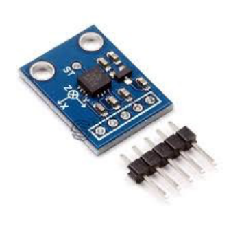
Fig 3.3: Accelerometer
As we are using the accelerometer sensor, a couple of nuts and bolts of the accelerometer
are as per the following:
Hardware, programming, and the client are melding in manners recently thought to be
the stuff of sci-fi. Hardware like gyroscopes, touch screens, and accelerometers is
enabling programming to recognize physical client subtleties. Never again is a keypad
the main decision for interacting with your telephone. On the occurrence of
straightforward gestures and movements can and do give a progressively common and
vivid client experience.
An accelerometer is characterized as an instrument for measuring the time rate of
change of speed concerning magnitude or bearing.
In our undertaking, we will utilize accelerometer to discover the speed of the vehicle
and the angle vehicle is measuring with the street for example the slope angle.
By measuring the measure of static acceleration because of gravity, you can discover
the angle the gadget is tilted at as for the earth.
3.1.3 The Global Positioning System (GPS)
The Global Positioning System (GPS) is a navigation system that is based on space which
provides the time and location related information in every weather phenomenon, be it at any
place near or on the Earth where there the line of sight to four or more GPS satellites is
obstructed.GPS RECEIVER: The Global Positioning System (GPS) is a satellite-based
route framework made up of somewhere around 24 satellites. GPS works in any climate
22
conditions, anyplace on the planet, 24 hours daily, with no membership charges or setup
charges. A GPS following unit is a gadget that employments the Global Positioning
System to decide the area of a vehicle, individual, or other resource for which it is
connected. This position will be recorded at normal interims. The recorded area
information can be put away inside the following unit, or it might be transmitted to an
information base (Central Location), or web associated PC, utilizing a cell (GPRS or
SMS), radio, or satellite modem inserted in the unit The square chart of the proposed
framework is appeared in the figure. The controller module is utilized to accumulate data
about potholes and bumps and their topographical areas and this data is sent to the server.
Ultrasonic sensor is utilized to measure the separation between the vehicle body and the
street surface and this information is gotten by the processor. The separation between
vehicle body and the ground, on a smooth street surface, is the limit remove. Limit esteem
relies upon the ground freedom of vehicles and can be designed in like manner. On the off
chance that the separation estimated by ultrasonic sensor is more noteworthy than the
edge, it is a pothole, in the event that it is littler, it is a protuberance else it is a smooth
street. The GPS beneficiary catches the area directions of the recognized pothole or the
protuberance.
The information about pothole accumulated by the proposed system is appeared on the LCD
and moreover send to the driver's mobile phone. The information fuses significance of the
pothole or stature of the projection what's more, its region encourages. The detachment
between the vehicle zone and the pothole territory set away in database is figured. In case the
detachment between the two is inside 100 meters, an alert message springs up on the screen.
In the application we will use, it will give the exact pothole location to the user.
An alternative would be that many of the smart phones, Androids have Assisted GPS
(AGPS)chips that are installed on them.
AGPS chips containing Android smart phones can also contain a receiving end for the
GPS satellites even in the absence of a proper network or a data plan. Instead, it
requiresthe time to synchronize with GPS satellites.
23

3.1.4 Raspberry Pi Board
It is similar in size to a PC which is credit card sized, which can be connected with any
HDMI input gadget or RCA video input gadget and a console is required for activity.
When it is introduced the HDMI and console are likewise not required for its task as you
would then be able to work it by different methods, for example, ssh for the interface of
command line and and VN C if graphical client the interface is wanted. The primary
specialized characteristics of the recent model of Raspberry Pi otherwise called Model B
have the following highlights:
• Ethernet RJ45 101100
• ARM CPU 700 MHz
• USB 2.0 x 2
• Composite RCA and HDMI (1.4)
• SDRAM 512 MB
The Raspberry Pi being little as a Visa server still has the abilities of working as a typical
PC it can play 10S0p goals recordings without lagging. It has a low cost moderately when
contrasted with machines in the market and can fill in as a server for light traffic, for
example, web traffic or DNS servers or NTP servers, which can keep running on low
power additionally for instance it very well may be controlled by versatile batteries which
can go about as UPS (Uninterrupted Power Supply), when there is a power cut and inform
about the power slice to the system directors.
24

Fig 3.4: Raspberry Pi Board
The Raspberry Pi runs Linux based operating frameworks and there is a specific variant
of Linux based bit known as Raspian which can run practically all programs which are
Linux perfect. Henceforth in this undertaking we have utilized 'python' content written in
python for movement recognition.
3.1.5 Arduino Uno Microcontroller
Fig 3.5: Arduino Uno
Arduino is a device on behalf of construction PCs with the purpose of canister classify
and organize a extra remarkable determine of the corporeal planet than your employment
post. The Arduino is linked by an assortment of sensors which drive their reading for
prepare to the Arduino. The a range of sensors this scheme has our: Ultrasonic feeler and
Accelerometer. It's an Open-source corporeal figure period contingent on a elementary
Microcontroller floorboard, and a movement fact for compose encoding for the panel.
Arduino be able to be used to build smart equipment, attractive commitment from a
assortment of switch or sensors, and calculating a grouping of light, motors, and extra
corporal yield. Arduino adventures stay singular, The sheet can exist accumulate by hand
or purchase preassembled. The Arduino indoctrination speech is an completing of cabling,
a next to corporal register point, relies winning meting out intellectual medium encoding
circumstance.
25
It was proposed to provide understudies a sensible & straightforward way of deal with
plan ordinary things. Going with clear Integrated Development Environment that
continuously runs on ordinary PCs and grant to create program for Arduino utilize C &C+
+.
There are different sundry Microcontrollers stages open for bodily register Phidgets,
Parallax, and a choice of others bid practically indistinguishable expediency. These
gadgets receive the disordered nuance of Microcontroller indoctrination & encompassing
it with an easy to-handle bunch. Arduino in like manner flourishes the route toward
working, offering some positions for educators, and understudies, and attracted learners
above a variety of structures:
• Cheap – the sheets of Arduino are commonly standing out from different other
microcontroller’s stages. The most conservative interpretation of the module could be
collected by hand, & the previously amassed modules cost less under expenditure plan.
• Compatibility - The Arduino programming continues running on Macs, OSX, Windows
and Linux running structures.
• Easy and discrete encoding condition - The Arduino programming condition is not stiff
to be used by amateurs, yet sufficiently flexible for flow edge customers to abuse too. To
educators, it could be accommodatingly established on the programming condition, so
understudies figure out ways to program in that condition will be alright with the
appearance of Arduino
• Broad programming & Open-source- The Arduino writing computer programs is
appropriated as unfasten font instrument, to be had for extension by practiced software
engineers. The idiom can be reach out through & C++ libraries, & public needing to
recognize the fastidious nuance could create the jump from Arduino to the C
programming language. In this manner, you could incorporate AVR-C code clearly into
Arduino programming.
• Convenient equipment & Open-source and - The Arduino relies upon the
microcontroller of Atmel. The strategy for the module is appropriated underneath a
26

artistic Commons grant, experienced course originators be able to make their self
variation of the unit, expanding & improving it. In reality, commonly fresh customers
could develop the board variation of the unit to perceive how it capacities and put aside
some money.
Difference between Microcontrollers & Microprocessors
Table 3.1: Difference between microprocessor and microcontroller
3.2Software Requirements
3.2.1 Arduino IDE: The Arduino Software is an Integrated Development Environment
(IDE) which outfits us by a utterance computer which cause us make the policy to be
exchange to the Arduino. This is completed utilize the Java speech and the code write in
program the board is specific language which is only a great deal of C & C++ limits. It is
wished-for to make acquainted to encoding with masters & various amateurs fresh to
indoctrination enhancement. It fuses rules critique chief with features, for instance,
27

sentences structuring feature, propagation coordinate, & modified space, and similarly
geared up for incorporate and transfer project to the floorboard by means of a solitary
tick. A program or code created for Arduino is known as a "Sketch". It was written in the
Java programming language. It is utilized to both, compose and transfer different projects
to sheets good with Arduino, yet in addition, with the assistance of outsider centers, other
merchant advancement sheets.
Arduino programs are written in C & C++. The Arduino IDE, go by an item files called
"Wiring" beginning the opening Wiring make an effort, making various typical
information assignments much more straightforward. IDE (Integrated Development
Environment) which is executed on our PCs is utilized to both, compose and transport PC
code to substantial board. The customers then simply need to describe two abilities to
build a runnable cyclical ability agenda:
• Setup(): a facility which run previously at the initiate of series that canister there settings
• Loop(): a faculty which is call more than once until the board control is set to off.
Figure 3.6ARDUINO IDE
28

On Arduino IDE, to code, a file is created which is said to be a sketch. The sketch is later
booted on the Arduino board which also eventually performs the required data collection
and more processing tasks according to the code.
Fig 3.7Arduino Sketch
3.2.2 Python IDE and PySerial Module:
This is the python language IDE (Integrated Development Environment). The data is sent
by the Arduino. It uses a serial communication to the PC also later that data is processed
with python after writing a python script. The access for the serial ports is encapsulated
by the PySerial Module. It fetches everything that is coming from the arduino using
library of pySerial.Serial port access is given using this module which in turn allows the
communication viathe same. It also gives a common API across the very different
operating systems, including Linux, BSD and Windows
29

Fig 3.8: Python IDLE
3.2 Design& Diagrams
Fig 3.9: The block diagram of the data collection and the analysis process
Fig 3.10: Sequence diagram
30

Fig 3.11: Database connection diagram
3.3 Algorithmic functions
3.3.1 getVals()
Receive the input from ultrasonic sensors & accelerometer
3.3.2 sendData()
Send data serially using Bluetooth module to android smartphone every 2 seconds
3.3.3 getData()
Receive the data sent by Bluetooth module serially
3.3.4 isDetected()
check if data is abnormal i.e. above threshold value
3.3.5 pinPoint()
Get Longitude and Latitude (eg. 37.459545, -122.125468) from Google Maps API and
pin it on Google Maps
3.3.6 average()
Calculate average every 2 seconds
31

3.3.7 Connecting to Whatsapp
32
3.3.8 Algorithm
constinttrigPin = 9; // defines pins numbers
constintechoPin=10;
long duration; // defines variables
intdistance;
voidsetup()
{
pinMode(trigPin, OUTPUT); // Sets the trigPin as an Output
pinMode(echoPin, INPUT); // Sets the echoPin as an Input
Serial.begin(9600); // Starts the serial communication
}
void loop()
{
digitalWrite(trigPin, LOW); // Clears the trigPin
delayMicroseconds(2);
digitalWrite(trigPin, HIGH); // Sets trigPin on HIGH state for 10 micro seconds
delay(100);
digitalWrite(trigPin, LOW);
duration = pulseIn(echoPin, HIGH); //Reads echoPin, returns sound wave travel time
distance= duration*0.034/2; // Calculating the distance
Serial.print("Distance: ");
Serial.println(distance); // Prints the distance
if(distance > 25)
Serial.println("this point needs repair");
}
33

Fig 3.12 Ultrasonic Module Algorithm
3.4 Computational
Accelerometer
The values which will be taken from the sensor would be analog and later will be
stored into a variable. The analog input from the sensor is required to map between x-
axis (100-110); y-axis (230-270) ; z-axis (110-120)because elevation reading is
measured. So, mapping for this can be done using the follow function:
map(output_value,420,20,0,150).
The reading for the sensor in low elevation is 100 and for high elevation it is 250. So,
we mapped it from the range of 100-250 using map function.
34

UV Sensor
Give strict, non-contact split estimation surrounded by a 3 cm to 3 m choice. A
simple pulse in/out communication needs only 1 I/O pin.
.
Table 3.2: Instrument specifications
3.5 Experimental
The following accident data from the government of India sources reiterate our need to
focus upon pothole detection and amendments.According to the data given by the police
department of different States and Union Territories, potholes make up for 6,424 road
accidents and hence 2,324 people killed during 2016.
[Source of Data:Government of India, Ministry of Road Transport & Highways,New Delhi]
Table 3.3: Road accidents, fatalities and injuries by vehicle type in 2016 and 2017
35

Fig 3.13: State-wise total accidents
Fig 3.14: Share of different vehicle types in road accidents in 2017
Chapter-4
36
PERFORMANCE ANALYSIS
4.1 Introduction
In chapter 4, we discuss the outcome we got in our project of Pothole Detection System
usingInternet of Things. Here in, we record the intensity of potholes, there location and
high slopes of roads is detected by our sensors. We will analyze the outcome of program
and the websiteinterface. We will also view the print screen of the program result.
4.2 Testing
Experiment 1: A solitary pothole on a flawlessly decent street.
On a consummately decent plain street, when the vehicle experiences a pothole, for this
situation when the avoidance of the edge in the accelerometer went down to - 15O and
back to 5O, proposes that there is a pothole in that area. At the point when the pothole is
distinguished than the GSM instantly tracks the area of the pothole and send it to the
cloud which is considered the application on an android telephone.
Experiment 2: Multiple potholes on street.
On a street, when the vehicle experiences different potholes, for this situation with a
diversion of the edge in the accelerometer redirecting all the more every now and again
then it proposes that there are various potholes out and about. At the point when the
potholes are identified then the GSM tracks all the area of the potholes and sends it to the
driver.
4.3 Result of Programming
When a pothole comes near or below this device, its details gets recorded.
Both, ultrasonic and accelerometer sensor is activated.
And then a notification is sent to Whatsapp that some pothole has been detected.
The notification to Whatsapp mentions that a pothole has been detected.
Okay, now the detection is taking place and we can observe it by looking at the
output window.
37

Fig 4.1:Whatsapp Notification
Fig 4.2:Alert on Whatsapp
Chapter-5
38
CONCLUSION
5.1 Conclusions
From the project competed up to now, we can reason that this framework can demonstrate
to be a promising framework. Whenever executed on a substantial scale, spilling
information can give us intriguing insights. Furthermore, this framework can distinguish
false cautions and ready messages, which is exceptionally urgent part. Besides, the
information from this sensor can ad lib the earlier outcomes from different frameworks.
As per the constant street conditions assessment, the strange street condition can be
distinguished and spared in rush hour gridlock focus. The drives of the vehicles can be get
adjacent street data from different vehicles by means of dynamic warring signs or to deal
with their pouring practice for recuperating heavy security, solace and effectiveness.
5.2 Future Scope
The framework can be made helpful as a piece of keen city crusade. Additionally,
applying AI methods in arranging information can assist the framework with adapting to
changing components like nature of the street and vehicle type the clients use.
Furthermore, the information gathered can be sent to the legislature with the goal that
they can take the consideration for improving the street conditions.
1) First step is store every one of the information for example client data and street
condition information (knocks and sharp turns with their precise area) on a server which
is completely scrambled.
Encryption will guarantee that security of the client is safe and this ways street conditions
can be all around checked and clients can be furnished with full subtleties of the street
while he is driving on it for example on the off chance that any sharp turn or knock is
arriving. This would make driving increasingly protected and secure.
2) In the event that the client is driving in a territory where there is no net availability, at
that point the application ought to hold every one of the information in the telephone's
inner memory itself and when the web association is again settled the whole information
is sent to the server. That is we will attempt to make our system defer tolerant.
39
3) To make the application react to crisis naturally. On the off chance that an unexpected
brake is connected after which the vehicle quits moving, the server will make an
impression on the application to know whether client is fine.
4) The affirmation of this message will be time delicate. On the off chance that the client
reacts back to the server's message on schedule, at that point client will be recorded safe
and in the event that no reaction is acquired in a specific term of time, at that point the
server will consequently send crisis to vehicle's present area.
40

REFERENCES
[1] A. Carullo and M. Parvis, “An ultrasonic sensor for distance measurement in
automotive applications,” IEEE Sensors J., vol. 1, no. 2, pp.143–147, Aug. 2001.
[2] A. Mednis, G. Strazdins, R. Zviedris, G. Kanonirs, and L. Selavo, “Real time pothole
detection using Android smartphones withaccelerometers,” in Proc. Int. Conf.
Distrib.Comput. Sensor Syst. Workshops, Jun. 2011, pp.1–6.
[3] F. Orhan and P. E. Eren, “Road hazarddetection and sharing with multimodal sensor
analysis on smartphones,” in Proc. 7th Int. Conf.Next Generat. Mobile Apps, Services
Technol.,Sep. 2013, pp. 56–61.
[4] GPS. NMEA Data. [Online]. Available:http://www.gpsinformation.org/
dale/nmea.htm, accessed Oct. 19, 2014.
[5]Harper Finch Lawyers,SpeedDetectionMethods.Availableon:
[http://www.trafficlawqld.com.au/HarperFinchLawyers2056/Page/21590/SpeedDetection
Methods.aspx].
[6]K. Chen, M. Lu, X. Fan, M. Wei, and J. Wu,“Road condition monitoring using on-
board threeaxis
accelerometer and GPS sensor,” in Proc. Int.ICST Conf. Commun. Netw. China, Aug.
2011, pp. 1032-1037
[7] M. Strutu, G. Stamatescu, and D. Popescu, “A mobile sensor network based road
surface monitoring system,” in Proc. 17th Int. Conf. Syst.Theory, Control Comput.
(ICSTCC), Oct. 2013, pp.630–634.
[8] P. More, S. Surendran, S. Mahajan, and S. K.Dubey, “Potholes and pitfalls spotter,”
IMPACT,
Int. J. Res. Eng. Technol., vol. 2, no. 4, pp. 69–74,Apr. 2014.
[9] R. Sundar, S. Hebbar, and V. Golla,“Implementing intelligent traffic control system
for congestion control, ambulance clearance, andstolen vehicle detection,” IEEE Sensors
J., vol. 15, no. 2, pp. 1109–1113, Feb. 2015.
[10] S. B. S. Murthy and G. Varaprasad, “Detectionof potholes in autonomous vehicle,”
IET Intell.
Transp. Syst., vol. 8, no. 6, pp. 543–549, Sep. 2013.
[11] S. Hegde, H. V. Mekali, and G. Varaprasad,“Pothole detection and inter vehicular
communication” in Proc. IEEE Int. Conf. VehicularElectron. Safety (ICVES), 2014, pp.
84–87.
[12] S. S. Rode, S. Vijay, P. Goyal, P.Kulkarni, andK. Arya, “Pothole detection and
warning system:
Infrastructure support and system design,” in Proc.Int. Conf. Electron. Comput. Technol.,
Feb. 2009,
pp. 286–290.
[13] S. Venkatesh, E. Abhiram, S. Rajarajeswari,K. M. Sunil Kumar, S. Balakuntala, and
N. Jagadish, “An intelligent system to detect, avoidand maintain potholes: A graph
theoreticapproach,” in Proc. 7th Int. Conf. Mobile Comput.Ubiquitous Netw., 2014, p. 80.
[14] X. Yu and E. Salari, “Pavement potholedetection and severity measurement using
laserimaging,” in Proc. IEEE Int. Conf. EIT, May 2014,pp. 1–5.
