
mch089 1 of 26
Geological Society of America
Map and Chart Series MCH089
2002
Geology of Nevado de Toluca Volcano and
surrounding areas, central Mexico
*Armando García-Palomo, José Luis Macías, José Luis Arce
Instituto de Geofísica, Universidad Nacional Autónoma de México, Coyoacán 04510, México D.F., México
Lucia Capra
Instituto de Geografía, Universidad Nacional Autónoma de México, Coyoacán 04510, México D.F., México
Victor Hugo Garduño
Departamento de Geología y Mineralogía, Instituto de Investigaciones Metalúrgicas,
Universidad Michoacana de San Nicolás de Hidalgo, Morelia, Michoacán, México
Juan Manuel Espíndola
Instituto de Geofísica, Universidad Nacional Autónoma de México, Coyoacán 04510, México D.F., México
ABSTRACT
Nevado de Toluca is an andesitic-dacitic stratovolcano of Pliocene-Holocene age
located in central Mexico. The volcano is built on a complex sequence of metamorphic
and sedimentary formations of Jurassic-Cretaceous age, rhyolitic ignimbrites of late
Eocene age, and massive andesitic lava flows of late Miocene. In the northwest corner
of the map area, on top of this basement sequence, a complex andesitic-dacitic strato-
volcano, San Antonio, and a series of andesitic-dacitic domes and cones of Pliocene–
early Pleistocene age were also built. The first andesitic-dacitic emissions of Nevado de
Toluca occurred 2.6 Ma and continued during late Pleistocene–Holocene time contem-
porarily with basaltic to dacitic emissions of the Chichinautzin Volcanic Field in the
eastern parts of the map area.
Volcanism in the area has been controlled by the interplay of three fault systems
active since late Miocene. These systems, from older to younger, are the Taxco-Querétaro
Fault System (NNW–SSE), the San Antonio Fault System (NE–SW), and the Tenango
Fault System (E–W). Nevado de Toluca was built at the intersection of these three fault
systems, which have influenced its volcanic history as evidenced by at least three sector
collapses and several large explosive eruptions. The Pliocene to Holocene volcanism at
Nevado de Toluca and the late Pleistocene–Holocene activity at Chichinautzin Volcanic
Field, together with the regional tectonic activity and recent seismic swarms, suggest that
the Tenango Fault System represents an active segment within the Trans-Mexican Vol-
canic Belt. The potential reactivation of either this fault system or Nevado de Toluca Vol-
cano would pose earthquake and/or volcanic hazards to more than 25 million inhabitants
in the vicinity, including large cities such as Toluca and Mexico.
García-Palomo, A., Macías, J.L., Arce, J.L., Capra, L., Garduño, V.H., and Espíndola, J.M., 2002, Geology of Nevado de Toluca Volcano and surrounding areas,
central Mexico: Boulder, Colorado, Geological Society of America Map and Chart Series MCH089, 26 p.
1
*Present address: Instituto de Geologia, Universidad Nacional Autónoma de
México, Coyoacán 04510, México D.F.; E-mail: [email protected]

INTRODUCTION
The Trans-Mexican Volcanic Belt (TMVB) is a 1200-km-
long continental arc, predominantly of andesitic-dacitic composi-
tion, extending westward across central Mexico and ending
nearly at the Gulf of Mexico (Fig. 1). Volcanoes of the Trans-
Mexican Volcanic Belt are generally viewed as resulting from the
subduction of the Cocos and Rivera plates beneath the North
American plate along the Middle American Trench (MAT)
(Ponce et al., 1992; Singh and Pardo, 1993; Pardo and Suarez,
1993, 1995). Other authors suggest that the Trans-Mexican Vol-
canic Belt is related to a crustal fracture zone or to a mega-shear
(Cebull and Shurbet, 1987). More recently Márquez et al. (1999)
have proposed the existence of a mantle plume and the subduc-
tion of the Cocos and Rivera plates as coexisting mechanisms to
explain several geochemical features of the belt. Sheth et al.
(2000) argue against this hypothesis, and proposed rather that the
Trans-Mexican Volcanic Belt represents a rift-like structure that is
experiencing active extension.
Recent petrological studies, particularly Osmium isotopic
analyses, reveal that magmatism of the Trans-Mexican Volcanic
Belt shows assimilation of the lower crust (Chesley et al., 2000).
These results correlate with the study of the Chichinanautzin
Volcanic Field (CVF) by Verma (2000), who concluded that
andesites and dacites were derived from partial melting of an het-
erogeneous mafic granulite from the lower crust, while alkaline
magmas are mantle derived mafic-magmas.
The beginning of volcanic activity in the Trans-Mexican Vol-
canic Belt has been controversial. In the western part of the
Trans-Mexican Volcanic Belt, Gastil et al. (1979) placed the
beginning circa 4.5 Ma, while Allan (1986) placed the oldest
known calc-alkaline volcanism at 10 Ma. According to Mooser et
al. (1974), volcanism in the central Trans-Mexican Volcanic Belt
started 30 Ma ago, whereas in the eastern Trans-Mexican Vol-
canic Belt, Cantagrel and Robin (1979) suggested a beginning
some 20 Ma ago. From stratigraphic studies in western and cen-
tral Trans-Mexican Volcanic Belt, Pasquaré et al. (1991) found
that the oldest units consisted of massive fissure-vent lava flows
(basaltic andesites to rhyolites in composition) to which they
gave the general name of “Basal Sequence.” Two samples from
this sequence yielded K-Ar ages of 8.1 Ma (sample from south
of Querétaro) and 7.8 Ma (sample from 15 km north of Morelia).
The Trans-Mexican Volcanic Belt is dominated by huge,
geologically young andesitic stratovolcanoes, some of which
form short north-south volcanic chains younger toward the south,
i. e., toward the trench. Examples are Cantaro-Nevado de Col-
ima-Colima, Telapón-Iztaccíhuatl-Popocatépetl, and Cofre de
Perote-Las Cumbres-Pico de Orizaba (see Fig. 1). K-Ar data for
the andesitic calc-alkaline volcanoes Sanganguey and San Juan
in the western Trans-Mexican Volcanic Belt indicate that cone
construction began circa 0.6 and 0.2 Ma, whereas in central
Trans-Mexican Volcanic Belt (Iztaccíhuatl-Nevado de Toluca)
cone growth began 1.7 and 2.6 Ma ago, respectively. This age
progression in the onset of growth of the andesitic volcanoes
along the Trans-Mexican Volcanic Belt and the trenchward
migration of volcanism suggest different subduction rates
between the Cocos and Rivera plates (Nixon et al., 1987; Pardo
and Suarez, 1995; Ferrari et. al., 1999).
In this work, we present the stratigraphy, distribution, and
structural setting of rock units around Nevado de Toluca Volcano
and surrounding areas. We summarize the petrological affinities
of the stratigraphic units as a basis for elucidation of the volcanic
evolution of the region, which in turn bears on the problem of the
beginning of volcanic activity in the Trans-Mexican Volcanic
Belt. Particular emphasis is given to the complex fault systems in
the region, which have affected the basement complex upon
which the andesitic-dacitic stratovolcanoes have been built since
the late Pliocene. For our study we reviewed several regional geo-
logical maps (De Cserna and Fries, 1981; Sánchez-Rubio, 1978;
Bloomfield,1975; Elías-Herrera,1993; Ramírez-Espinosa,1977).
The study area covers about 4000 km
2
, encompassing six quad-
rangle maps (scale 1:50 000) published by Instituto Nacional de
Estadística Geografía e Informática (INEGI). Geological data
were collected and compiled with the aid of these topographic
maps. The topographic contour lines, geological contacts and
faults, and cultural features were then combined into a single digi-
tal product at a 1:100 000 scale. For the description of the map
units, we follow customary usage in published works as employed
by García-Palomo (1998) and García-Palomo et al. (2000).
Tectonic setting of central Mexico
The Trans-Mexican Volcanic Belt consists of three distinc-
tive segments, each with its own tectonic, volcanological, and
petrological characteristics (Pasquaré et al.,1987) (Fig.1). These
segments are the western Trans-Mexican Volcanic Belt, domi-
nated by the Colima-Chapala-Tepic triple junction where both
alkaline and calc-alkaline volcanic products are present; the cen-
tral Trans-Mexican Volcanic Belt, characterized by disperse
andesitic-dacitic stratovolcanoes, silicic calderas, and mono-
genetic cone fields where calc-alkaline volcanism is dominant;
and the eastern Trans-Mexican Volcanic Belt, characterized by
andesitic-dacitic calc-alkaline stratovolcanoes and some alkaline
products. Under this scheme, the Nevado de Toluca is located
along the boundary between the central and eastern segments.
According to the tectonic model of Mexico proposed by
Johnson and Harrison (1990), Nevado de Toluca Volcano is
located within the Guerrero Block (Fig. 2). This block is confined
to the north by the Chapala-Tula fault system and to the south by
the Chapala-Oaxaca fault system. In this model, Nevado de
Toluca astrides a series of NNW–SSE trending normal faults,
forming a Basin-and-Range like pattern (Demant, 1978; Suter et
al., 1992), and a series of E-W trending normal faults (Fig. 2).
These two fault systems were originally identified as major frac-
tures in the Toluca–Mexico City area (Mooser, 1969; Mooser and
Maldonado-Koerdell, 1961). Based on satellite imagery, Flores
(1978) concluded that Nevado de Toluca Volcano lies at the inter-
section of NW-SE and NE-SW fault systems. However, in these
2 A. García-Palomo et al.
mch089 2 of 26

general studies no data are available on the kinematics of the fault
systems. Recently, García-Palomo et al. (2000) concluded that
Nevado de Toluca Volcano was built upon the intersection of
three fault systems named Taxco-Querétaro (NNW-SSE), San
Antonio (NE-SW), and Tenango (E-W), respectively.
Nevado de Toluca Volcano
The Nevado de Toluca Volcano (19° 09′N; 99° 45′W,
4 680 m.a.s.l.), the fourth highest peak in Mexico, is located
about 23 km southwest from the city of Toluca, capital of the
State of Mexico. Nevado de Toluca is also known as “Xinantécatl,”
a Náhuatl term meaning “Nude Man.” Romero-Quiroz (1959)
argued that this word does not have solid Náhuatl roots and pro-
posed instead the word Tzinacantépetl, or Bat Mountain. How-
ever, García-Martínez (2000), through comprehensive research
of the historical archives, recently concluded that the most appro-
priate Náhuatl name for Nevado de Toluca is “Chicnauhtécatl,”
meaning Nine Hills.
Nevado de Toluca is a large andesitic-dacitic stratovolcano
of Late Pliocene–Holocene age (Bloomfield and Valastro, 1974;
Cantagrel et al., 1981; this work). The northern flanks of the
mch089 3 of 26
Geology of Nevado de Toluca Volcano and surrounding areas, central Mexico 3
Figure 1. Location of Nevado de Toluca
Volcano and other volcanic features of the
Trans-Mexican Volcanic Belt (TMVB).
Other Quaternary volcanoes are: 1—
Ceboruco, 2—La Primavera, 3—Colima,
4—Parícutin, 5—Los Azufres, 6—
Amealco, 7—San Antonio, 8—Jocotitlán,
9—Popocatépetl,10—Iztaccihuati. MAT—
Middle American Trench.
Figure 2. Map showing prominent NE–SW and NW–SE
trending fault systems associated with the Trans-Mexican
Volcanic Belt (after De Cserna et al., 1988; Johnson and
Harrison, 1990; Nieto-Samaniego et al.,1995). The heavy-
line box shows the map area in central Mexico. Volcanoes
shown are: PO—Pico de Orizaba, CP—Cofre de Perote,
NT—Nevado de Toluca, C—Colima, Ma—La Malinche,
TE—Telapon, TL—Tlaloc, I—Iztaccíhuatl, J—Jocotitlán,
and P—Popocatépetl. Cities shown are MC—Mexico
City, T—Toluca, PU—Puebla, Q—Querétaro, O—Oax-
aca, CHI—Chilpancingo, MO—Morelia, and G—Guadala-
jara. Fault systems shown include the Oaxaca fault (OF),
the Tenochtitlán fault system (TFS), the Chapala-Oaxaca
fault system (CHOFS), and the Chapala-Tula fault sys-
tem (CHTFS). Other structures are the Tepic Graben
(TG), the Colima Graben (CG), and the Penjamillo
Graben (PG) (after Siebe et al., 1999).

volcano are made of coalescent fans of pyroclastic materials
spreading toward the Lerma Basin. This basin encloses the City
of Toluca de Lerdo and the lakes of Chiconahuapan and Lerma,
which are drained by the Lerma River toward the Pacific Coast.
The relief of Nevado de Toluca with respect to the Lerma River
basin is 2100 m. The southern flanks of Nevado de Toluca consist
of incised valleys that drain to the Chontalcoatlán River and
thereafter to the Pacific Ocean. The volcano rises circa 2700 m
with respect to the towns of Ixtapan de la Sal and Tonatico
located on its southern flanks (Fig. 3).
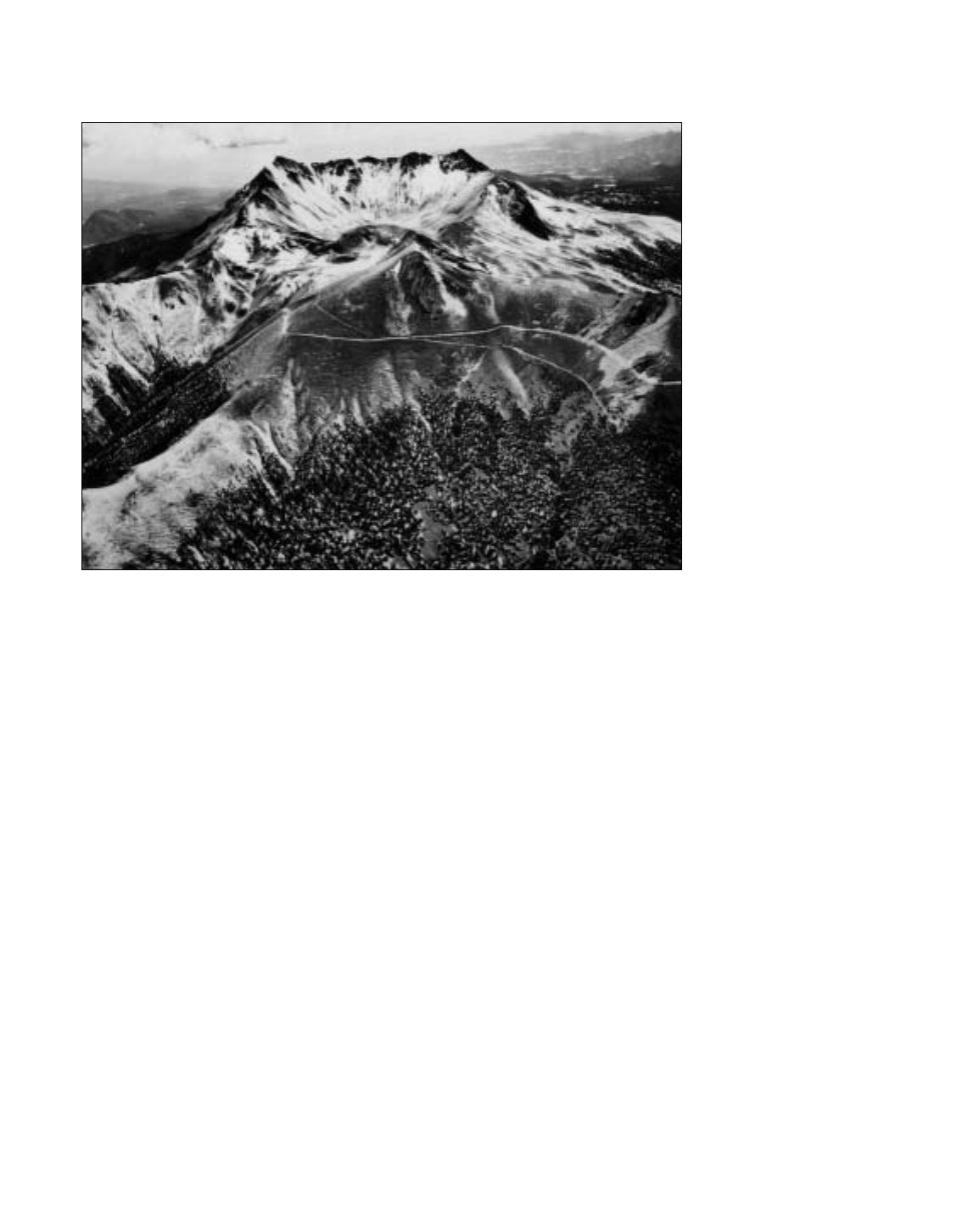
The summit crater of Nevado de Toluca is roughly elliptical
(approximately 2 ×1.5 km) with its major axis trending E-W; it has
a horseshoe shape opened to the east (Fig. 4). The present crater
rim is composed of two or more remnants of older crater structures,
appearing in air photographs and satellite imagery as straight walls
intercepting at high angles. The western crater wall contains rem-
nants of lava flows and domes that are well observed toward the
uppermost part of the wall (Fig. 5). The crater contains two lakes
(Lake of the Sun and Lake of the Moon) separated by a dacitic
dome intrusion known as El Ombligo (Spanish word meaning
navel). The surface of floor of these two alkaline lakes (5.6 pH;
Armienta et al., 2000) is about 4,200 m.a.s.l., and both contain
diatom flora (Caballero-Miranda,1996). Pre-Hispanic pottery and
obsidian blades are commonly found on the surface of the central
dome and in the deep waters of the lakes; apparently these pottery
shards are the remains of offerings made by the Aztecs or by earlier
dwellers such as the Matlazincas (Quezada,1972).
The volcano’s morphology shows the effect of glacial
advances during the Holocene (Heine, 1988). Rock glaciers and
debris flows derived from glacial activity are well exposed on
both flanks of the present crater. Despite some hydrothermally
altered areas within the crater, there are no signs of modern
hydrothermal activity on the volcano.
STRATIGRAPHY
In our study area we have recognized and mapped seventeen
stratigraphic units, as shown in the geologic map and the compos-
ite stratigraphic column diagram on the map sheet (located above
the legend). A description of each unit follows.
Mesozoic
Guerrero Terrane. The Guerrero Terrane forms most of the
western part of Mexico, is one of the largest terranes of the North
American Cordillera, and is characterized by an Upper Jurassic-
Lower Cretaceous volcanic-sedimentary sequence of arc affinity
(Centeno-García et al., 1993). In the study area, the Guerrero
Terrane consists of three formations: the Ixtapan-Teloloapan
sequence, the Acuitlapan Formation, and the Amatepec Forma-
tion. These formations are described below.
The volcano-sedimentary metamorphic Ixtapan-Teloloapan
sequence consists of conglomerates, limestones, sandstones, and
lava flows affected by greenschist facies metamorphism (Campa
et al., 1974). Based on the presence of ammonites and other
invertebrates, Campa et al. assigned this unit to late Jurassic-early
Cretaceous. This sequence is exposed in the southern portion of
the area close to Ixtapan de la Sal, Zumpahuacán, and Coatepec
de Harinas, where it consists of long narrow outcrops oriented
NW–SE. Its base is not exposed in the area, and it is overlain by
Tertiary and Quaternary volcanic rocks.
In the Taxco region, the Acuitlapan Formation consists of
interbedded gray to green shales and poorly sorted graywackes
formed by feldspar and quartz grains derived from metamor-
phic and volcanic rocks (Fries, 1966). In the Santa Rosa area,
this formation consists of meter-thick interlayering of meta-
morphosed carbonates, arenites, and lutites. These rocks are
well bedded, foliated, rather friable, and weather to a buff or tan
color. The calcareous portion is gray and more resistant to
weathering than the other lithologies. The main outcrops of this
formation are located to the southwest of the study area. Accord-
ing to its ammonite assemblage, the age of this unit is early
Jurassic (Tolson, 1993).
The Amatepec Formation (De Cserna, 1983), which is
exposed in the southwestern portion of Nevado de Toluca Vol-
cano, consists of dark, bluish-gray to black limestones with cen-
timeter-thick bands of white calcite and quartz. Locally, thin beds
of black silicic and slate rocks are intercalated with the lime-
stones, suggesting that the probable protolith of these rocks was
pelagic micritic limestone, with thin cherts and shales. The lime-
stone is dark gray, with thin and laminated beds with dark-gray
shale intervals. The age of the Amatepec Formation is Cretaceous
(Albian-Cenomanian) (De Cserna, 1983).
Guerrero Morelos Platform. The Guerrero Morelos Plat-
form includes the Morelos and Mexcala formations of Tithon-
ian-Coniacian age (De Cserna et al., 1974a). This map unit
consists of massive to thickly bedded limestones and dolomitic
limestones associated with calcareous terrigenous rocks toward
the upper portion of the sequence. In the study area it is exposed
around Zumpahuacán, where it forms NNW–SSE trending
open anticline-syncline folds with the same alignment. Here,
the Morelos Formation is exposed, and consists of light-gray
dolomitic limestones with chert bands of massive to metric bed-
ding stratification. The thickness of the unit varies from place to
place from few meters up to 1000 m (De Cserna and Fries,
1981). This unit is in normal-fault contact, with the volcanic
rocks of the Tepoztlán Formation of middle Miocene age.
Cenozoic: Eocene
Intrusive Felsic Igneous rocks. This unit includes a small
stock of quartz-rich porphyritic dacite dated at 55 ± 6 Ma by
De Cserna et al. (1974b) (Table1). This intrusive body is located
in the southwestern part of the mapped area close to the towns of
Almoloya de Alquisiras and Malinaltenango. They form an elon-
gate dome-like structure with northwesterly trend, the maximum
elevation of which (~2,000 m.a.s.l.) rises to about 300 m above
the depressions filled with volcaniclastic sediments to the east.
4 A. García-Palomo et al.
mch089 4 of 26

mch089 5 of 26
Figure 3. Landsat image of the map area showing NT—Nevado de Toluca, SA—San Antonio Volcano, TA—Tenango Andesite, T—City of Toluca,
IX—Ixtapan de la Sal, To—Tonatico, VG—Villa Guerrero, C—Coatepec, and M—Malinalco.
Cenozoic: Eocene-Oligocene
The Balsas Formation. The Balsas Formation consists of
calcareous conglomerates, lava flows, sandstones, volcanic silt-
stones, and lacustrine deposits (Fries, 1956; 1960), with a maxi-
mum thickness of 500 m (De Cserna and Fries, 1981). This
formation ranges in age from Upper Eocene to Early Oligocene
and probably represents a late stage of Laramide tectonism that
affected the pre-Cretaceous rocks of this region. Its distribution
within the map area is limited to scarce faulted and tilted outcrops
southeast of the town of Malinalco. Here, the Balsas Formation is
represented by red polymictic conglomerates that consist of
rounded to subrounded clasts (1-5 cm in diameter) set in a red-
dish matrix of silty sand. The formation overlies the limestones of
the Morelos Formation with an angular unconformity.
The Tilzapotla Formation. The Tilzapotla Formation was
originally described as a sequence of rhyolites, rhyodacites,
dacitic lava flows, and pyroclastic flow deposits of early Oligo-
cene age as its lower age limit (Fries, 1960). Recently, Morán-
Zenteno et al. (1999), in their study of the Tertiary Volcanic
Province of Southern Mexico (TVPSM), recognized three series
of rocks distributed south of the Trans-Mexican Volcanic Belt:
the Taxco volcanic sequence of rhyolitic composition (31-38 Ma,
Table1); the Buenavista-Quetzalapa volcanic sequence of mainly
andesitic-dacitic composition (24-31 Ma, Table 1) but including
the Tilzapotla Rhyolite; and the Huautla volcanic sequence of
dominantly andesitic composition as yet not dated.
Outcrops of this formation are best exposed in the southern
part of the map area near the towns of Porfirio Díaz and Chiltepec,
where they form large and extensive plateaus, locally intruded by
felsic dikes. In these localities, the Tilzapotla Formation is com-
posed of several units of pink ignimbrite, as thick as 300 m, with
white pumices and crystals of quartz, plagioclase, and biotite
imbedded in a vitric matrix.
Based on its stratigraphic position, Fries (1960) proposed the
age of the Tilzapotla Formation as early Oligocene. Rocks from
this Formation yielded K-Ar ages of 26 Ma (Fries, 1960), 31.9
± 0.9 Ma (Morán-Zenteno et al., 1999), and 49 ± 3 Ma (Linares
and Urrutia-Fucugauchi, 1981) (Table 1). We obtained a K-Ar
date of 38.3 ± 1.0 Ma for a sample from this sequence. This age,
together with the areal distribution of these rocks in the southern
portion of the study area, just north of the City of Taxco, suggest
that this unit correlates with the lower unit (Acamixtla Forma-
tion) of the Taxco volcanic sequence dated at 38.2 ± 1 Ma (K-Ar
method) (Morán-Zenteno et al., 1999).
The Tilzapotla Formation unconformably overlies the Bal-
sas Formation and is overlain with parallel unconformity by the
lava flows of the Basal Sequence.
Cenozoic: Miocene
The San Nicolás Basaltic Andesite. The San Nicolás Basaltic
Andesite is composed of a series of dark-gray, vesicular lava
flows with thickness as great as 100 m (García–Palomo et al.,
2000). They are of basaltic-andesitic composition, aphanitic tex-
ture, and contain zeolite-filled vesicles. The rock is hypocrystalline
and is characterized by an intersertal texture with scarce pheno-
crysts of orthopyroxene, clynopyroxene, olivine, plagioclase set
in a groundmass rich in microlithes of the same minerals, oxides,
and glass. The olivine and pyroxenes have reaction borders to
6 A. García-Palomo et al.
mch089 6 of 26
Figure 4. Aerial view to the west of Nevado
de Toluca with the crater open to the east.
The dacitic central dome “ombligo”
appears in the central part of the crater as
well as the Moon lake, whose surface
stands at ca. 4200 m.a.s.l. (photo by A.
Herrera).

iddingsite. The primary oxide minerals are titanomagnetite and
chromite, and spinel occurs as inclusions in phenocrysts.
These andesites crop out in the vicinity of San Nicolás, a
town located SE from Nevado de Toluca, where they overlie the
Tilzapotla Rhyolite in sharp erosional contact, which may repre-
sent a gap of approximately 10 Ma. García-Palomo (1998)
obtained a K-Ar age of 21.6 ± 1.0 Ma for this unit, corresponding
to early Miocene (Table1).
The Tepoztlán Formation. The Tepoztlán Formation con-
sists of massive lahars rich in subrounded porphyritic andesite
clasts intercalated with fluvial deposits (Fries, 1960; De
Cserna and Fries, 1981). This formation is widely exposed
south of the Trans-Mexican Volcanic Belt in the proximities
of the towns of Tepoztlán, Cocoyoc, and Oaxtepec. The flu-
vial deposits show a wide diversity of stratification types
(cross-bedded, normal grading, etc.), syn-sedimentary faults,
and occasionally, clastic dikes and cut and fill structures as
observed at the entrance of the Malinalco pre-Hispanic ruins.
This map unit is well exposed in the vicinity of the village of
Malinalco and in scattered sites southeast of Nevado de
Toluca (Fig. 6). The total thickness of the Tepoztlán Forma-
tion varies from 200 to 700 m, although close to Malinalco it
pinches out between the San Nicolás Basaltic Andesite and the
overlying Basal Sequence. The exact age of this formation is
mch089 7 of 26
Geology of Nevado de Toluca Volcano and surrounding areas, central Mexico 7
Figure 5. View of the northwest wall of the
Nevado de Toluca crater interior showing
dark-gray lava flows and domes exposed
toward the uppermost portion of the wall.
The Sun Lake appears in the foreground of
the photograph (photo by J.L. Macías).
Figure 6. View of the upper part of the
Tepoztlán Formation at the pre-Hispanic
ruins of Malinalco. Around AD 1400, the
archaeological site of Malinalco was used
by the Aztecs as a training site for their
warriors. This site was carved in lacus-
trine and hyperconcentrated flow deposits
of the Tepoztlán Formation (photo by J.L.
Macías).

still uncertain, but Fries (1960) assigned it to Early Miocene.
The K-Ar dates of the San Nicolás Basaltic Andesite (21.6
± 1.0 Ma, Table 1) and the Basal Sequence above it brackets
this unit within the middle Miocene (García-Palomo, 1998).
The Basal Sequence. The Basal Sequence consists of
interbedded dark-gray lava flows and breccias of andesitic com-
position (García-Palomo et al., 2000). These rocks commonly
have reddish weathered surfaces, show cooling fissures, and
reach a total thickness of 400 m. This sequence is extensively
exposed in the western and eastern parts of Nevado de Toluca
and forms the Tenancingo, Desierto del Carmen, and Chiltepec
ranges. Fries (1960) and Elías-Herrera (1993) grouped this
sequence within the Andesita Zempoala, a series of undifferen-
tiated rocks of late Miocene-Pliocene age. Our field observa-
tions suggest that this sequence is not related to the Andesita
Zempoala, because its age and lithologic characteristics are dif-
ferent. Mineralogically, rocks of the Basal Sequence typically
have microlithic to ophitic texture; and are composed essen-
tially of plagioclase (andesine-labradorite) and minor amounts
of hypersthene and hematite set in a microlithic groundmass
composed of the same constituents.
A whole-rock K-Ar date of this sequence yielded an age of
7.5 ± 0.4 Ma which places this unit in late Miocene (García-
Palomo, 1998; Table 1). According to its age, and because it
unconformably overlies the Tepoztlán Formation (García-
Palomo, 1998), the Basal Sequence can be correlated with rock
of the basaltic sequence of the Querétaro, Morelia, and Río
Grande regions (6-8 Ma) which are inferred to have formed during
the early episodes of formation of the Trans-Mexican Volcanic
Belt (Pasquaré et al., 1991; Ferrari et al., 1994).
The San Antonio Volcanic Sequence. We group under the
name of San Antonio Volcanic Sequence all rocks forming the
San Antonio Volcano (Sánchez-Rubio, 1978). The summit of the
volcano (19º10’ N, 99º52’ W; 3,680 m.a.s.l.) has a truncated
crater opened to the NE; the volcano is cut by NE-SW trending
faults and deep incised valleys (Fig. 3).
The main edifice of San Antonio is composed of a thick
sequence of lava flows, overlain by pyroclastic materials consist-
ing of thick pumice-rich plinian fall layers that are overlain by
pumiceous pyroclastic flow deposits and surges, such as those
observed at Loma de San Francisco (Fig. 7). Sequences of thick
block-and-ash flow deposits are also exposed on the northern
flanks of the volcano close to the town of Santa María del Monte.
A sample from the upper part of the San Antonio sequence
yielded an age 3.0 ± 0.2 Ma (Table 1). On the basis of its strati-
graphic position, the morphology of the edifice, and the perva-
sive fracturing and weathering of the rocks, we consider the early
stages of formation in middle Miocene.
The San Antonio lavas are porphyritic with as much as 40%
phenocrysts, mainly of plagioclase and hornblende, together with
lesser amounts of biotite, augite, olivine, or enstatite. The ground-
mass is hyalopilitic with small crystals of plagioclase, clinopy-
roxene, and Fe-oxides (Sánchez-Rubio, 1984).
Sierra de las Cruces Sequence. The Sierra de las Cruces
Sequence (SCS) is located in the eastern part of the study area
and separates the basins of Mexico and Lerma. The Sierra de las
8 A. García-Palomo et al.
mch089 8 of 26
TABLE 1. K/AR AND OTHER DATES FOR SELECTED ROCKS FROM THE MAP AREA
Map Unit Sample Rock Type Material dated 40*Ar (ppm) 40K (ppm) 40*Ar/K Age Ref
12b NT01 D WR 0.000148 1.965 0.000075 1.3 ± 0.1 Ma 7
12b Me19 A WR 1.3 ± 0.3 Ma 2
11 SJ B-A WR 0.000146 1.796 0.000081 1.4 ± 0.1 Ma 1
12b VnE5 A WR 1.44 ± 0.07 Ma 2
12b Ne20 A WR 1.6 ± 0.15 Ma 2
12a NT05 A WR 0.000301 2.017 0.000149 2.6 ± 0.2 Ma 7
8 SN1 A WR 0.000306 1.754 0.000174 3.0 ± 0.2 Ma 1
9 BMS3 B-A WR 0.000799 1.84 0.000434 7.5 ± 0.4 Ma 1
5BIBWR 0.000971 0.769 0.001261 21.6 ± 1.0 Ma 1
4BV-12 I Hb 0.000831 0.573 0.001450262 24.8 ±1.3 Ma 6
4BV-17 R Pl 0.00155 0.869 0.001783659 30.5 ± 1.1 Ma 6
4 TX-10 R Pl 0.001259 0.68 0.001851471 31.6 ± 1.2 Ma 6
4 TX-25 G WR 0.008059 4.315 0.001867671 31.9 ± 0.8 Ma 6
4SOL-5 D Bt 0.01753 9.372 0.001870465 31.9 ± 0.8 Ma 6
4 TX-21 R Bt 0.01588 8.364 0.001898613 32.4 ± 0.8 Ma 6
4 TX-16 G WR 0.01081 5.686 0.001901161 32.4 ± 0.9 Ma 6
4 En19 R WR 36.9 ± 1.3 Ma 4
4 CH1 R WR 0.00911 4.045 0.002252 38.3 ± 1.0 Ma 1
4 TX-4 G WR 0.009415 4.201 0.002241133 38.2 ± 1.0 Ma 6
M48-51 R WR 49 ± 3 Ma 3
Ig LG-22 D Pb/alpha /mg-hr=2522 Pb=55 (ppm) 55 ± 6 Ma 5
B—Basalt, A—Andesite, D—Dacite, R—rhyolite, G—Glass, I—Ignimbrite, WR—Whole Rock, Hb—Hornblende, Pl—Plagioclase, and Bt—Biotite.
1
García-
Palomo et al. (2000),
2
Bloomfield and Valastro (1987),
3
Linares and Urrutia-Fucugauchi (1981),
4
De Cserna and Fries (1981),
5
De Cserna et al. (1974b),
6
Alva-Aldave et al. (1996), and
7
This work.

Cruces Sequence was initially described by Schlaepfer (1968)
and Sánchez-Rubio (1984). This range has a general NNW–SSE
orientation. It is formed by several andesitic stratovolcanoes such
as San Miguel, La Corona, Picacho, Zempoala, and Ajusco. In
addition, there are other volcanic structures, mostly domes,
calderas, and scoria cones. Every volcano comprised within the
SCS is made up of pyroclastic flow and fall deposits, lava flows,
and thick sequences of lahar and avalanche deposits associated in
occasions with collapse structures. This sequence pinches out
against the lacustrine, fluvial, and alluvial deposits of the Lerma
Basin. Las Cruces sequence is capped by the younger rocks of
the Chichinautzin Volcanic field and rests discordantly on top of
the Tepoztlán Formation. The age of the Sierra de las Cruces
sequence is considerably variable, going from 13 to 6 Ma in the
northern part (Aguirre-Díaz and Carrasco-Hernández, 1999), 7 to
5 Ma at the Catedral caldera (Aguirre-Díaz et al., 1999), 2.87 to
0.39 Ma in the south (Mora-Alvarez et al., 1991), and to 3.4 to
0.6 Ma at Ajusco Volcano (Romero-Teran, 1998).
Pliocene-Pleistocene
Cones and domes complex. A single map unit, designated
as monogenetic lava cones and domes,
comprises all rocks from
a series of monogenetic volcanic structures distributed around
Nevado de Toluca and San Antonio volcanoes. The lava cones
characteristically have a basaltic andesitic composition and are
exposed in the San Miguel region, where they are crudely aligned
in a NE-SW direction (García-Palomo et al., 2000). Some of
these volcanic centers have open craters with collapse structures
toward the southwest (e.g., Las Palomas). The domes are
andesitic to dacitic, strongly affected by erosion and fractures,
and dispersed throughout the area. The dacites (e.g., San Jose) are
holocrystalline with trachytic texture composed of abundant
plagioclase microlithes that surround the scarce phenocrysts of
plagioclase and pyroxenes, quartz, amphibole, and olivine. Fe-
oxides are present as inclusions in phenocrysts and dispersed
throughout the sample.
A K-Ar date of the San Jose lava flow was obtained from a
whole-rock concentrated yielding an age 1.4 ± 0.1 Ma (Table1).
From this date and its stratigraphic position, we assigned a
Pliocene-Pleistocene age to this unit.
Pleistocene-Holocene
Nevado de Toluca Volcano. The first geological studies of
Nevado de Toluca Volcano were carried out during the first dec-
ade of the twentieth century (Ordoñez, 1902; Otis, 1902; Flores,
1906; Waitz, 1909). These authors described the general fea-
tures of the volcano, including its morphology, structure, and
petrology. Bloomfield and Valastro (1974, 1977) and Bloom-
field et al. (1977) were the first authors to define the individual
eruptions of the volcano on the basis of radiocarbon chronol-
ogy. They identified several events: a vulcanian eruption about
28 000 yr. BP that produced extensive blue-gray lahars; a plin-
ian eruption that deposited the Lower Toluca Pumice fall ca.
24 000 yr. ago; and another plinian eruption that generated the
Upper Toluca Pumice ca. 11600 yr. BP.
Cantagrel et al. (1981) divided the rocks forming Nevado
de Toluca into two main units. The oldest unit corresponds to a
series of light-gray porphyritic andesitic lava flows that consti-
tute the main edifice of the volcano. These rocks are common
accessory components in younger volcaniclastic and pyroclastic
units and are easy to identify because of their pink-to-red alter-
ation surfaces. The lavas are composed of plagioclase, clinopy-
roxene, and orthopyroxene set in a glass groundmass (Cantagrel
et al., 1981). These deposits crop out near the town of Raíces
mch089 9 of 26
Geology of Nevado de Toluca Volcano and surrounding areas, central Mexico 9
Figure 7. Sequence of pumice fall (black
arrows) and pyroclastic flows exposed on
the northern flanks of San Antonio Volcano
(photo by J.L. Macías).

along the road connecting Coatepec de Harinas and the crater of
the Nevado de Toluca. The K-Ar age of these lavas falls
between 1.60 ± 0.12 and 1.23 ± 0.15 Ma (Pleistocene) (Canta-
grel et al. 1981; Samples Ne20, VnE5, and Me19, Table 1).
However, we recently collected a sample from a sequence of
lava flows exposed on the southern flank of Nevado de Toluca,
which yielded a K-Ar age of 2.6 Ma (sample NT05, Table 1),
being in consequence the oldest products of Nevado de Toluca
Volcano. These lavas were fed by a N-S dike system now highly
dissected and exposed by erosion at several outcrops. These
lavas are porphyritic andesites, with plagioclase, clinopyroxene,
and resorbed hornblende phenocrysts set in a groundmass com-
posed of glass and plagioclase microphenocrysts. The dikes
also cut through an older ignimbrite deposit, unfortunately so
altered that further study on its origin is impossible. We also
dated a dacitic clast found within a debris avalanche deposit
exposed in the southern flanks of the volcano; this clast is very
probably a fragment of the younger edifice and yielded an age
of 1.3 Ma (sample NT01, Table 1) in agreement with the ages
obtained by the above mentioned authors.
The younger unit of Cantagrel et al. (1981) is made up of a
complex sequence of pyroclastic deposits that mantle the flanks
of Nevado de Toluca Volcano. In the northern part, they form
coalescent fans, whereas in the south they were channeled into
NW-SE-trending tectonic basins. This unit is composed of volca-
niclastic deposits (debris flows and fluvial deposits), a debris
avalanche, a debris flow, pyroclastic flow, and surge and fall
deposits, all of which were emplaced during the last 100,000
years (Bloomfield and Valastro, 1974, 1977; Bloomfield, 1975;
Macías et al., 1997; Capra and Macías, 2000). The activity of
Nevado de Toluca between these two periods (~1.5 Ma and
<0.1 Ma) was presumably volcaniclastic, according to Cantagrel
et al. (1981). Numerous volcaniclastic, laharic, and minor lacus-
trine deposits are exposed in the southern flanks of Nevado de
Toluca, where deep canyons have been cut by erosion. In con-
trast, the northern flanks of the volcano have a rather youthful
morphology covered by younger deposits that bury older rocks.
We next summarize the Quaternary stratigraphic record of
Nevado de Toluca (Fig. 8).
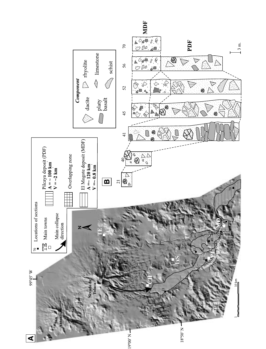
Older debris avalanche (DAD-1) and cohesive debris flows
(PDF and MDF) deposits. Macías et al. (1997) first recognized
two debris avalanche deposits emplaced during the Pleistocene
toward the S-SE of the volcano (out to a maximum distance of
55 km). The older deposit (DAD-1, Fig. 9) is constituted by a sin-
gle unit, 10-m thick, massive, matrix supported, and monolitho-
logic with dacitic clasts that vary in diameter from centimeters to
1.5 m. Unfortunately, because outcrops of this older unit are
scarce, no additional information is available. In contrast, detailed
work by Capra and Macías (2000) showed that the younger sec-
tor collapse produced two large cohesive debris flows: the Pil-
caya (PDF) and the El Mogote (MDF) deposits. These covered
an area of 220 km
2
and involved a total volume of 2.8 km
3
(Fig. 10a). The PDF has a sharp basal contact, and a flat surface.
Only in the medial area is hummocky morphology present, with
mounds up to 20 m high. Its thickness varies from 6 m in the
proximal section to 40 m in the intermediate zone, where thick-
ening is abrupt (Fig. 10b); assuming an average thickness of
20 m, we obtained a total volume of 2 km
3
.
The PDF unit consists of a massive, matrix-supported
deposit containing megaclasts up to 15 m in diameter with jig-
saw puzzle structures. It is heterolithologic in composition and
contains fragments of the andesite and dacite of the older edifice
as well as rocks from the local bedrock, such as andesite and
basalt of the Miocene Basal Sequence, limestone of the Balsas
Formation, schist of the Ixtapan-Teloloapan Formation, rhyolite
from the Tizapotla Formation, conglomerate and lacustrine frag-
ments of the Tepoztlán Formation. The matrix is sandy (as much
as 80% sand fraction) and contains up to 16% clay (olinite-smec-
tite) in the proximal areas. Sorting improves and mean grain size
decreases downstream.
The MDF deposit rests directly on top of the Pilcaya unit
(PDF), cropping out at 40 km from the edifice and extending out
75 km with an average thickness of 6 m (Fig. 10B). It covers an
area of 120 km
2
for a total volume of 0.8 km
3
. It consists of a
massive, matrix-supported deposit, with clasts as large as 1 m in
diameter of the same composition of the Pilcaya deposit. The
matrix is sandy (as much as 78% sand) and contains as much as
6% in clay fraction.
From the textural and sedimentological characteristics of
these deposits, we infer that the flank failure occurred because of
intense hydrothermal alteration and tectonic dissection of the old
edifice of the Nevado de Toluca Volcano. Increase of pore pres-
sure, perhaps combined with seismic activity associated with
movements of the Tenango normal fault, could have liquified a
portion of the southern part of the edifice, resulting in a debris
avalanche that transformed directly into a cohesive debris flow.
Subsequent heavy rains then caused the remobilization of the
upper part of the PDF, triggering secondary lahars from which
the MDF deposited.
Pink Pumice Flow (42 ka). A thick, pink pumice-rich pyro-
clastic flow deposit is exposed around Nevado de Toluca Vol-
cano. The deposit consists of at least four units composed of
rounded to semirounded vesiculated pumice fragments set in a
sandy matrix, in which tree trunks have been found (Fig. 11, site
95). This unit represents the oldest radiocarbon-dated material at
42,030 +3530/
–
2445 yr. BP (Macías et al., 1997). Because no
other deposits indicative of dome-destruction events have been
found associated with the Pink Pumice Flow, we assume that the
eruption that produced it took place under open-vent conditions,
most likely after the collapse of the volcano that produced the Pil-
caya debris flow.
Block-and-ash flow deposits (37, 32, 28, 26, 14 ka). The
volcanic activity of Nevado de Toluca during late Pleistocene has
been characterized by cataclysmic eruptions, some of which are
related to the partial or total destruction of central dacitic domes.
Because these deposits are similar in appearance and compo-
nents, previous authors considered them as a single unit, which
they referred to as either “older lahar assemblages” (Bloomfield
10 A. García-Palomo et al.
mch089 10 of 26

and Valastro, 1974, 1977) or “Nueés Ardentes” (Cantagrel et al.,
1981). Bloomfield and Valastro (1977) estimated the age of the
deposits at ca. 28,000 yr. BP, based on a single
14
C date from a
paleosoil that covers the deposit. However, Macías et al. (1997)
identified two block-and-ash flows, the older of which was dated
as 37 000 ± 1125 yr. BP, which they correlated with the date of
35600 +2600/
–
1800 yr. BP for the “gray lahar” of Heine (1988)
and an underlying paleosoil dated at 38,000 yr. BP by Cantagrel
et al. (1981). The younger block-and-ash flow deposit yielded
ages of 28140 + 865/
–
780, and 28925 + 625/
–
580 yr. BP. These
ages correlate with the upper age limit proposed by Bloomfield
and Valastro (1977), who reported an age of 27580 ± 650 yr. BP
for a fluvial gravel on top of the flow deposit (Table 2).
The block-and-ash flows have entirely blanketed and modi-
fied the morphology of the volcano’s flanks and apron, and at
present most of the localities of these deposits are pits used for
the extraction of construction materials. The northern flanks of
the volcano consist of coalescent tongues of block-and-ash flow
deposits that produce a subdued morphology. All other flanks of
the volcano are highly dissected and show the action of tectonism
and strong erosion, with exposure of the block-and-ash flow
deposits cropping out as isolated tongues along major ravines.
From stratigraphic and radiometric age evidence, five
block-and-ash flow (BAF) deposits have been identified at
Nevado de Toluca with dates of about 37, 32, 28, 26, and 14 ka
(see Fig. 8 and Table 2). Eruptions at 37, 28, and 14 ka were
produced by the destruction of large central dacitic domes that
occupied the volcano’s central crater. This interpretation is sug-
gested by the roughly radial pattern of exposures of pyroclastic
deposits, although the oldest two also show important ponded
deposits. The aspect, texture, composition, and chemistry of
juvenile products are very similar for all deposits; therefore,
paleosoils and/or charcoal fragments were very useful in identi-
fying individual units.
The 37 and 28 ka deposits consist of massive block-and-ash
flow deposits (commonly more than 10 m thick) composed of
mch089 11 of 26
Geology of Nevado de Toluca Volcano and surrounding areas, central Mexico 11
Figure 8. Composite stratigraphic column of Nevado de Toluca Volcano (after Macías et al., 1997).

more than three flow units of which the uppermost has a pink-red
color, probably suggesting oxidation due to contact with the
ambient air. These flow deposits contain charred logs and
fumarolic pipes, and are associated with minor pyroclastic surge
deposits. Both flow deposits are composed of gray porphyritic
juvenile lithics with minor amounts of pumice, glassy lithic
clasts, and red-oxidized dacite clasts from the volcanic edifice.
The juvenile lithic clasts have millimeter-sized phenocrysts of
plagioclase, hornblende, augite, and minor hypersthene, quartz,
and biotite embedded in an aphanitic groundmass of the same
constituents. Pumice and dense juvenile lithic clasts have a uni-
form chemical composition in the range of 65 to 67% in SiO
2
(Table 3 and Macías et al., 1997).
The 14 ka block-and-ash flow deposit differs strikingly from
the other two because it has a more radial distribution around the
volcano. A typical proximal section of this unit consists, from the
base upward, of a gray cross-bedded surge deposit (15 cm thick)
overlain by two massive gray block-and-ash flow units made of
gravel to boulder size lithics set in a coarse sand-size matrix with
a total thickness of 10 m (Fig. 12, Section 268). In other localities
(e.g. Section 35), the basal surge is rather thick (30-40 cm) with
well-developed cross bedding and accretionary lapilli as large as
1cm in diameter, capped by a massive pink ash flow deposit with
few gravel size lithics embedded in a fine sand matrix (Fig. 11).
In distal areas (20 km northeast from the vent), this unit has been
found in subaerial exposures (Newton and Metcalfe, 1999) and in
drill holes at the margins of Lake Chiconahuapan (Caballero et
al., 2001) (Fig. 11). At this distance, the 14 ka event is repre-
sented by a gray, massive ash flow about 90-cm thick composed
of fine sand- to silt-size particles. Organic-rich material collected
some 50 cm above this layer at pit La Isla II yielded an age of
13 870 +445/
–
420 yr. BP; for which Caballero et al. (2001)
assigned an approximate age for this unit of >14000 yr. BP. How-
ever, at Site 256, a paleosoil sample lying below the block-and-
ash flow deposit yielded an age of 13160 ± 89 yr. BP. Therefore
the age of this event remains uncertain.
12 A. García-Palomo et al.
mch089 12 of 26
Figure 9. Stratigraphic correlation of the Late Pleistocene deposits around Nevado de Toluca Volcano. Abbreviations of deposits are UTP—Upper
Toluca Pumice, LTP—Lower Toluca Pumice, BAF—Block-and-ash flow, PDF—Pilcaya Debris Flow, and DAD1—Debris Avalanche Deposit 1.
mch089 13 of 26
Figure 10. A: Digital elevation model showing the distribution of the Pilcaya (PDF) and El Mogote (MDF) cohesive debris-flow deposits on the southern flanks of Nevado de Toluca Volcano. TE—
Tenago, CH—Coatepec Harinas, IxS—Ixtapan de la Sal, PI—Pilcaya, and MO—El Mogote. B: Stratigraphic correlation of selected sections of the Pilcaya and El Mogote deposits (for locations see
Figure 10A).

Massive block-and-ash flows deposits represent the other
two events dated ca. 32 and 26 ka; however, they have a poor dis-
tribution around Nevado de Toluca. The scattered nature of out-
crops of these deposits probably reflects direct explosions or
partial collapse of the central dacitic domes or to burial by subse-
quent pyroclastic deposits.
Pumice Fall Deposits
Previous work described two plinian eruptions at the Nevado
de Toluca volcano. They were dated in ~24 500 and ~11 600 yr.
BP and named Lower Toluca Pumice and Upper Toluca Pumice,
respectively (Bloomfield and Valastro, 1974, 1977). Radiocarbon
ages were determined for paleosoil and carbonized material col-
lected below the deposits; however, no charcoal material was
collected in the deposits themselves. In this work, we recognize
four plinian eruptions (older to younger): Ochre Pumice Fall
(~36 000–37 000 yr. BP), Lower Toluca Pumice (~24 500 yr.
BP), White Pumice Flow (12 100 yr. BP), and Upper Toluca
Pumice (10 500 yr. BP) (see Table 1). Of these four units, only
the Ochre Pumice Fall was not previously reported (Macías et
al., 1997).
Ochre Pumice Fall (OPF). The Ochre Pumice Fall occurs
on the northern slope of Nevado de Toluca Volcano ~ 5 km from
the summit (Fig. 9, Section 268). From bottom to top, it consists
of an alternating sequence of pumice fall layers and surge and
flow deposits as follows: pumice fall layer (22 cm), surge deposit
(10 cm), thin pumice fallout (7 cm), surge and ash flow deposits
(62 cm total thickness), pumice fall (25 cm), and surge horizon
(10 cm). The fall layers (Fig. 12) consist of ochre vesiculated
pumice fragments and rare accidental lithic clasts. The sequence
is crowned by a pink pyroclastic flow deposit rich in gravel-size
pumice fragments set in a sand to silt size matrix (3–5 m thick).
Two charcoal samples from the second surge horizon and from
the base of the next fall layer yielded approximate ages of 39355
+1385/
–
1180 yr. BP, and 36780 +3325/
–
2345 yr. BP. These dates
bracket the age of the eruption as between 36 and 39 ka ago.
Lower Toluca Pumice (LTP). The Lower Toluca Pumice is
composed of an ochre fallout deposit with reverse grading and
an average thickness of 55 cm. It is separated from the 28 ka
BAF by an ash flow deposit and a dark-brown paleosoil, dated
at 24260 ± 670 yr. BP by Bloomfield and Valastro (1977). The
Lower Toluca Pumice is clast-supported and rich in ochre pum-
ice, with lesser amounts of clasts of gray dense juvenile dacite,
hydrothermally altered lithic clasts, and schist fragments from
the local basement. According to Bloomfield et al. (1977), the
Lower Toluca Pumice fallout contains approximately 62%
pumice, 27% lithic clasts, and 11% crystals. It covers an
approximate area of 400 km
2
and has a dispersal axis trending
northeast from the crater. The above authors calculated its vol-
ume at 0.33 km
3
(0.16 km
3
D.R.E. = dense rock equivalent).
However, the most complete exposures of this deposit
(Fig. 11, Section 62) show that the Lower Toluca Pumice is more
complex than previously described. The base of the unit always
consists of the pumice fall layer proper (LTP), which is overlain
by pale-brown cross-stratified surge deposits as thick as 35 cm,
rich in ochre rounded to subrounded pumice and lithic clasts. The
unit is then covered by a pale-brown ash flow deposit 42 cm
thick, which commonly shows clear signs of reworking toward
the top that ends with a poorly developed paleosoil.
White Pumice Flow (WPF). The White Pumice Flow con-
sists, from bottom to top, of three fallout members, and at least
two pyroclastic flow units (Fig. 9, Section 161). The lower fall-
out member (55 cm thick) has asymmetric grading (reverse to
normal) and poor sorting; it is rich in white pumice fragments,
lesser lithics, and abundant crystals of biotite, hornblende, and
plagioclase. The middle fallout member (7 cm thick) is com-
posed of fine sand grains (lithics, pumice, and crystals of horn-
blende, biotite, and plagioclase), and it shows high-angle
cross-lamination (laminae dark and white). The upper fallout
member (12 cm thick) has asymmetric grading and is composed
of coarse gravel of pumice, lithics (more than the basal mem-
bers), and crystals. At Section 161 it developed high-angle
cross-stratification, suggesting wind reworking during deposi-
tion (Fig. 13). Thin cross-stratified pyroclastic surges are
interbedded with the fallout layers. On top of the fallout
sequence lays the white pumice flow deposit, which consists of
two massive units; both have a minimum thickness of 15 m and
contain pumice and lithic fragments as large as 35 and 20 cm in
diameter, respectively. The pumice is dacitic (65.67% in SiO
2
)
and rich in phenocrysts of plagioclase, hornblende, biotite, and
quartz. The White Pumice Flow has been found mainly on the
southeast slopes of the volcano, with very thick exposures close
to Villa Guerrero and Tenancingo. This unit correlates with the
Lower Almoloya Tephra found in a pit drilled in the northwest-
ern edge of the Chiconahuapan Lake (Newton and Metcalfe,
1999); these authors dated an organic rich horizon below this
layer at 12400 ± 60 yr. BP. The White Pumice Flow is underlain
by a paleosoil dated at 26275 +1210/
–
150 yr. BP (Macías et al.,
1997); however, recent findings of charred logs within the pum-
ice flows at different outcrops (Fig. 11, Sections 161 and 200),
yielded ages of 12 414 +290/
–
280, and 12 040 ± 92 yr. BP (see
Table 2). Because the lower limit of the Lower Almoloya
Tephra has been dated at 12 400 ± 60 yr. BP, we consider the
approximate age of the White Pumice Flow eruption to be
closer to the 12040 ±92 yr. BP date, although additional dating
needs to be carried out to establish a more definite age.
Upper Toluca Pumice (UTP). The Upper Toluca Pumice
represents the largest plinian eruption at Nevado de Toluca Vol-
cano. Bloomfield and Valastro (1974, 1977) subdivided the
Upper Toluca Pumice into two members (Lower and Upper);
however, recent detailed studies of this deposit demonstrate that
the eruption was rather complex (Macías et al., 1997; Arce,
1999). Extensive field data attest that the Upper Toluca Pumice is
composed of four fallout horizons (PC0, PC1, PC2, and PC3),
that correspond to four plinian columns ~ 25, 37, 42, and 28 km
in height (Arce, 1999). Four pyroclastic flows (F0, F1, F2, and
F3) and two pyroclastic surges (S1, and S2) are included in this
14 A. García-Palomo et al.
mch089 14 of 26

mch089 15 of 26
Figure 11. Distribution of block-and-ash flow deposits around Nevado de Toluca Volcano. The locations of some key stratigraphic sec-
tions discussed in the text are indicated by a numbered open circle. Contour intervals every 100 m.

mch089 16 of 26
TABLE 2: RADIOCARBON AGES OF PYROCLASTIC DEPOSITS OF NEVADO DE TOLUCA VOLCANO.
Sample No. Lab. No. Age (yr. BP) Material dated Location Ref.
NT95140 A-8880 3,140 +195/-190 Charcoal in pumice flow deposit 19°02′19″, 99°54′34″ 1
NT96144B A-9175 3,435±50 Charcoal in ash flow deposit 19°13′26″, 99°47′22″ 1
MX9787C A-9926 4,200±110 Charcoal in dark-organic paleosoil 19°01′55″, 99°30′00″ 2
MX97455 A-9708 9170+160/-155 Charcoal in brown paleosoil 19°05′59″, 99°26′01″ 2
NT9570-A A-9173 10,445±95 Charcoal in pyroclastic flow of UTP 19°17′30″, 99°21′00″ 2
La Isla-2 A-9778 10,820±365 Charcoal in lacustrine sediment, jus below UTP 3
KBC-38 Tx-1658 11,580±70 Charcoal from thin layer at base of UTP; average of 4 samples 19°04′00″, 99°22′00′ 4
NT97200 A-9781 12040±92 Charcoal in White Pumice Flow deposit 2
NT96161 A-9472 12,415+290/-280 Charcoal in White Pumice Flow deposit 19°04′05″, 99°39′20″ 2
KBC-40a Tx-1660 13,620±150 Paleosoil 19°10′00″, 99°39′00″ 4
KBC-40b Tx-1661 13,870±180 Paleosoil 19°10′00″, 99°39′00″ 4
NT97193 A-9776 15,340+155/-150 Lacustrine organic horizon below block-and –ash flow deposit 19°13′37″, 99°28′45″ 3
MX9887D A-9921 16,215+135/-130 Paleosoil 19°01′55″, 99°30′00″ 2
KBC-40c Tx-1662 17,090±220 Humic horizon in Paleosoil just above reworked LTP 19°10′00″, 99°39′00″ 4
KBC-25 Tx-1604 20,100±140 Paleosoil on Pleistocene lavas below KBC-9; contaminated by modern humus 19°06′00″, 99°56′00″ 4
KBC-20 Tx-1599 21,030±430 Paleosoil on valley lahar 19°05′00″, 99°51′00″ 4
KBC-19 Tx-1598 21,170±170. Paleosoil on Tertiary lavas overlain by lahar: ?=KBC-17 and -18,
contamination suspected 19°04′00″, 99°52′00″ 4
KBC-26 Tx-1605 21,790±200 Paleosoil on valley lahar overlain by fluvial sand and gravel 19°11′00″, 99°51′00″ 4
KBC-9 Tx-1725 23,800± 490 Charcoal fragments in lithic ash at base of valley lahar , 2 samples 19°06′00″, 99°56′00″ 4
KBC-7 Tx-1523 23,940± 600 Paleosoil on lahar to E of Nevado: mean of 7 samples 19°12′00′, 99°39′00″ 4
KBC-42 Tx-1664 24,160±420 Thin peaty layer at base of valley lahar, W of Nevado 19°05′00″, 99°51′00″ 4
KBC-8 Tx-1524 24,260± 670 Paleosoil on lahar to E of Nevado: mean of 7 samples 19°10′00′, 99°39′00′ 4
KBC-15 Tx-1594 24,400±430 Paleosoil on Tertiary lavas; Sierra de Las Cruces 19°14′00″, 99°23′00″ 4
KBC-2 Tx-1518 24,410± 590 Paleosoil on lahar to E of Nevado: mean of 7 samples 19°04′00′, 99°39′00″ 4
KBC-18 Tx-1597 24,440± 550 Paleosoil on Tertiary lavas and old lahars to W of Nevado 19°03′30″, 99°52′30″ 4
KBC-17 Tx-1596 24,590± 280 Paleosoil on Tertiary lavas and old lahars to W of Nevado 19°03′00″, 99°52′30″ 4
KBC-4 Tx-1520 24,930± 670 Paleosoil on lahar to E of Nevado: mean of 7 samples 19°09′00″, 99°37′00″ 4
KBC-5 Tx-1521 25,020± 590 Paleosoil on lahar to E of Nevado: mean of 7 samples 19°09′30″, 99°37′30″ 4
KBC-6 Tx-1522 25,250± 760 Paleosoil on lahar to E of Nevado: mean of 7 samples 19°09′30″, 99°39′30″ 4
KBC-3 Tx-1519 25,620± 680 Paleosoil on lahar to E of Nevado: mean of 7 samples 19°12′00″, 99°41′00″ 4
NT9545 A-8485 26,273-1208/-1050 Paleosoil below the white pumice flow deposit 19°02′54″, 99°39′00″ 1
NT97204-B A-9782 26,610±320 Charcoal in block-and-ash flow deposit 19°07′05″, 99°40′50″ 2
KBC-41 Tx-1663 27,590±650 Paleosoil on fluvial gravel derived from lahar 19°05′00″, 99°51′00″ 4
NT9535B A-8244 28,140+865/-780 Charcoal in block and ash flow deposit 19°13′26″, 99°47′09″ 1
NT9521 A-8388 28,925+625/-580 Charcoal in ash flow deposit 19°00′24″, 99°38′56″ 1
MX9787A A-9927 31,450+660/-610 Brown paleosoil 19°01′55″, 99°30′00″ 2
NT9535-1 A-9315 32,730±50 Paleosoil below block-and-ash flow deposit 19°13′26″, 99°47′22″ 2
NT9521-A A-8389 32,860+2025/-1615 Charcoal in block-and-ash flow deposit 2
NT98268-C A-10000 36,780+3325/-2345 Charcoal in ochre pumice fall deposit 19°10′30″, 99°46′20″ 2
NT9550 A-8486 37,000 ± 1125. Charcoal in block and ash flow deposit 19°00′09″, 99°38′56″ 1
NE 12 CGR-4955 38,000 Paleosoil at Jaral gully 5
NT9595 A-8657 42,030+3530/-2445 Charcoal in ash flow deposit 19°12′52″, 99°45′44″ 2
Compiled data from:
4
Bloomfield and Valastro (1977),
5
Cantagrel et al. (1981), 1Macías et al., (1997),
3
Caballero et al., (2000), and
2
This work.

deposit (Fig. 14). The fallout layers of the Upper Toluca Pumice
covered portions of the Lerma and Mexico City basins with lay-
ers ~1 m and 10 cm thick, respectively; such areas presently con-
tain major population centers of Toluca and Mexico City, which
have a combined population of more than 25 million. These
deposits are composed mostly of pumice with minor amounts of
gray juvenile dacite, red-altered andesitic lithic clasts, and green-
altered dacite clasts. This pyroclastic sequence (fall, flow, and
surges) is well exposed at El Zaguan gully on the eastern flank of
Nevado de Toluca. The pyroclastic flow deposits are probably
those described by Palacio-Prieto (1988) at El Zaguan gully as
pumice-rich lahars, and by Bloomfield and Valastro (1977)
mch089 17 of 26
Geology of Nevado de Toluca Volcano and surrounding areas, central Mexico 17
TABLE 3.
C
HEMI
C
AL ANALY
S
I
S
O
F
S
ELE
C
TED
S
AMPLE
S
FR
O
M THE MAP AREA
Sample CH33 CH46 CH47 CH49 CH84 SJ BS3 BI NT30 NT54 NT84 NT90
SiO2 61.04 60.67 61.25 61.63 56.7 64.46 60.08 52.69 60.89 65.06 63.47 62.73
TiO2 0.75 0.77 0.8 0.8 0.82 0.58 0.78 0.79 0.77 0.58 0.65 0.70
Al2O3 15.92 16.12 15.97 16.01 16.07 15.72 15.5 16.33 16.44 16.21 16.60 16.32
Fe2O3 5.59 5.72 5.43 5.58 6.54 4.09 5.8 7.87 5.72 4.08 4.95 5.13
MnO 0.09 0.09 0.09 0.09 0.1 0.07 0.09 0.13 0.09 0.07 0.08 0.07
MgO 4.91 4.69 4.37 4 6.07 2.2 5.61 6.74 3.51 2.09 2.55 3.56
CaO 5.62 6.08 6.02 5.69 6.9 4.35 5.76 8.04 5.86 4.18 4.73 4.89
Na2O 4.38 4.24 4.25 4.39 3.99 4.18 4.02 3.68 4.22 4.34 4.39 4.32
K2O 1.56 1.62 1.7 1.86 1.41 1.98 1.95 0.83 2.20 2.29 1.98 1.86
P2O5 0.19 0.24 0.26 0.26 0.24 0.17 0.3 0.17 0.28 0.16 0.19 0.20
LOI -0.01 -0.01 -0.01 -0.01 0.12 1 0.08 0.86 0.14 1.43 0.57 0.66
Total 99.97 100.11 99.99 100.29 98.96 98.81 99.97 98.12 100.1 100.49 100.2 100.45
Ba 389 529 587 528 495 390 466 197 605 448 455 463
Rb 0.1 35 51 44 34 27 22 18 47 50 48 44
Sr 465 573 661 571 545 729 822 381 720 493 514 500
Y1717181818161617 20151820
Zr 137 169 176 174 149 135 161 94 175 149 149 152
Th 2.7 3.6 4.3 4 3.3 3.1 3.4 0.8 5.9 4.6 4.1 4
Pb 12 10 14 12 9 8 10 5 0 0 0 5
Zn 63 66 67 71 69 75 70 76 57 47 52 62
Cu 21 22 21 19 35 24 25 49 12 6 12 17
Ni 106 87 76 67 126 38 148 161 13 17 20 49
V 101 102 99 105 119 73 104 167 123 74 94 96
Cr 193 200 167 145 262 71.7 240 384 57.3 38.8 62.9 113
Hf 3.4 4.2 5.2 4.4 4 3.5 4 2.5 5.1 2.6 2.7 2.7
Cs 1.4 1.5 1.1 1.3 0.8 0.7 1 0.4 1.2 2.7 1.6 1.8
Sc 13.5 14.4 14.1 14.1 17.5 9.1 13.3 20.8 15.1 9 13.1 14.1
Ta 0.5 0.9 1.2 0.6 0.4 0.3 0.3 0.3 0 0 0 0
Co 48.4 54.9 51.5 56.7 43.9 16.6 22.6 33.8 33.9 16.9 19.9 20.5
Be 1 1111121 2112
U 1.1 1.4 4.3 1.7 1.1 0.9 1 0.1 2.2 1.5 2.2 1.5
W 260 271 283 322 139 23 1 14 124 34 39 37
Mo 1 1131222 3224
Au 1 111222344000
La 14.9 24.6 28.1 25.1 21.6 18.5 22.3 7.3 28.3 15.7 19.7 21.8
Ce 37 58 61 60 50 30 46 18 57 31 36 37
Nd 18 28 31 27 24 17 22 11 27 15 18 21
Sm 3.85 4.88 5.66 5.14 4.69 3.19 4.53 2.86 5.98 3.28 4.34 4.6
Eu 1.21 1.57 1.49 1.65 1.53 1.02 1.45 1 1.63 1.04 1.29 1.28
Tb 0.6 0.6 0.6 0.6 0.6 0.5 0.5 0.5 0.8 0.4 0.5 0.7
Yb 1.74 1.82 1.76 1.98 1.83 1.13 1.41 1.5 1.9 1.43 1.88 1.95
Lu 0.26 0.27 0.26 0.28 0.23 0.17 0.22 0.24 0.28 0.22 0.28 0.29
N19°13′ 19° 04′ 19° 07′ 19° 06′ 19° 01′ 19° 09′ 19° 05′ 18° 58′ 19° 03′ 19° 01′ 19° 02′ 19° 03′
W99°26′ 99° 25′ 99° 28′ 99° 31′ 99° 27′ 99° 58′ 99° 37′ 99° 30′ 99°47′ 99° 47′ 99° 45′ 99° 43′
Note: Major elements reported in weight percentages, minor and trace elements in ppm.
Samples are: CH—Holocene scoria cones and lava flows of the Chichinautzin Volcanic Field, SJ—San José, cones and domes complex, BS3—Basal Sequence,
and BI—San Nicolás Basaltic-Andesite.
All samples were analyzed for major elements by Inductively coupled plasma-direct current (ICP-DC), and for trace elements by Instrumental neutron activation
analysis (INAA), at Activation Laboratories, Ancaster, Canada.

southeast of Tlanisco as “pink valley-fill lahars.” Cantagrel et al.
(1981) also saw similar deposits in some cuts of the Rio Grande
and correctly catalogued them as “coulées pyroclastiques pon-
ceuses” although they considered them an independent event
apart from the Upper Toluca Pumice eruption.
The chemical composition of juvenile products is dacitic,
ranging from 61 to 65% silica (Macías et al., 1997; Arce, 1999).
The pumice and juvenile lithic clasts consist of crystals of plagi-
oclase, orthopyroxene, and hornblende with minor biotite and
oxides set in a glassy vesiculated groundmass.
Bloomfield and Valastro (1974, 1977) obtained a minimum
age of 11 600 yr. BP on the basis of
14
C dates obtained from
samples collected at the base of the unit (Table 2). New radio-
carbon dates of a sample found within the basal pyroclastic
flow deposit yielded an age of 10 445 ± 95 yr. BP (Macías and
Arce, 1997; Arce, 1999). These data, along with a radiocarbon
date of 10 820 ± 365 yr. BP for a sample from the La Isla II drill
hole taken just below of the Upper Toluca Pumice layer
(Caballero et al., 2001) and the revised data available in the lit-
erature, suggest that the Upper Toluca Pumice eruption
occurred some 10 500 years ago.
The Chichinautzin Volcanic Field
The Chichinautzin Volcanic Field (CVF) represents the
youngest volcanic activity in the area and consists of a series of
predominantly basaltic-andesitic scoria cones (e.g., Tres Cruces
Volcano, Holotepec) and fissure-fed lava flows (e.g., Tenango).
These volcanic edifices, which constitute only the western part
of the Chichinautzin Volcanic Field are located in the eastern-
most portion of the study area. The age of the volcanic centers
of the Chichinautzin Volcanic Field varies from 38000 to 1500
years BP (Bloomfield 1974, 1975; Martin del Pozzo, 1982;
Velasco-Tapia and Verma, 2001; Siebe, 2001). The Upper
Toluca Pumice deposit, which was produced by a large plinian
eruption of Nevado de Toluca some 10 500 yr. BP, represents
an excellent marker to distinguish between late Pleistocene and
Holocene rocks within this western edge of the The Chichin-
autzin Volcanic Field (Fig. 15A). Based on stratigraphic rela-
tions, it is obvious that fissure-vent lava flows and cinder cones
related to the E–W Tenango fault system are mainly Holocene.
Alternatively, scattered scoria cones in the Lerma Basin are pre-
Upper Toluca Pumice and are bracketed between 38 000 and
10500 yr. BP.
The late Pleistocene stratigraphic sequence of this region of
the Chichinautzin Volcanic Field can be further subdivided into
two groups based on the stratigraphic position of the scoria fallout
layers derived from the Negro Cone that has a main dispersion
axis to the NW. A paleosoil below this fallout horizon yielded an
age of 19 530 ± 160 yr. BP (Bloomfield, 1975); therefore, the old-
est group of cones includes Quilotzi and Pehualtepec, while the
younger group, with ages between 19 530 and 10 500 yr. BP,
includes Capulhuac, Cuautl, and others (Fig. 15B).
Geochemistry
Twelve new chemical analyses of major, trace, and rare-earth
elements were performed on the volcanic rocks in the study area.
These results, combined with those of previous work, represent a
total of 53 calc-alkaline and 18 alkaline rocks plotted on the clas-
sification diagram of Figure 16 (Bloomfield and Valastro, 1974;
Macías et al., 1997, Morán-Zenteno et al., 1999; Marquez et al.,
1999; Wallace and Carmichael, 1999; Verma, 1999). Young prod-
ucts belonging to Nevado de Toluca Volcano and older units have
calc-alkaline affinity (Fig. 16). However, a few samples from the
central and eastern parts of the Chichinautzin Volcanic Field
18 A. García-Palomo et al.
mch089 18 of 26
Figure 12. Panoramic view of Site 268
where the Ochre Pumice Fall deposit is
well exposed on the northern flanks of
Nevado de Toluca Volcano.

overlap the alkaline field (Bloomfield, 1975; Márquez et al.,
1999; Wallace and Carmichael, 1999).
The Nevado de Toluca samples plot in the andesite and
dacite fields, ranging from 55 to 67% SiO
2
. Rocks of the western
Chichinautzin Volcanic Field have mainly andesitic composition,
in particular the Holocene scoria cones and fissure-fed lava flows.
The rocks of the Tilzapotla Formation are mainly rhyolites and
represent the most differentiated eruptive products in the area
(Fig. 16). The San Nicolas Basaltic Andesite plots in the left part
of the basaltic andesite field, while the Basal Sequence falls in
the andesitic field.
The andesites and dacites of Nevado de Toluca Volcano have
MgO values (1.5–3.5 wt%) and slightly differ from the andesites
and dacites of the Chichinautzin Volcanic Field (4–7.2 wt%
MgO), as was previously recognized by Wallace and Carmichael
(1999). Alkaline products of the Chichinautzin Volcanic Field
have MgO values between 6 and 10 wt% that plot in the upper left
corner of Figure 17A. Three clusters of samples grouped accord-
ing to their MgO concentrations are evident in Figure 17A:Toluca
andesites, Toluca dacites, and Chichinautzin calc-alkaline, alkaline
and the older Basal Sequence, and San Nicolás Basaltic Andesite
rocks. Other Harker diagrams, however, show that Nevado de
Toluca samples plot separately from the Chichinautzin calc-alka-
line and alkaline rocks and the Basal Sequence and San Nicolás
Basaltic Andesite samples (Fig. 17B–D). A similar behavior is
observed in the abundances of Ni, V, and Cr among the trace ele-
ments, with the San Nicolás Basaltic Andesite being the more
mafic sample (Fig. 17C). The silica versus alkalis diagrams clearly
show the alkaline rocks of the Chichinautzin Volcanic Field to be
distinct from the rest of the samples (Fig. 17E–F).
Figure 18 shows the spider diagram for ten of our twelve
chemical analyzed rocks, in which the Nevado de Toluca vol-
canics define a gray-shaded pattern. The Nevado de Toluca rocks
fit well in respect to the Trans-Mexican Volcanic Belt with LREE
(La, Ce, and Nd) enrichments between 30 to 60 times and deple-
tions of HREE (Tb, Yb, and Lu). The San Jose Dacite (1.3 Ma)
follows the same pattern as the Nevado de Toluca rocks. The
youngest calc-alkaline Chichinautzin samples are slightly
enriched in light REE with respect to the Toluca samples; sur-
prisingly, the Basal Sequence (7.5 Ma) shows a similar pattern.
The only sample that diverges from this general trend is the
San Nicolas Basaltic Andesite (21 Ma), which shows smaller
mch089 19 of 26
Geology of Nevado de Toluca Volcano and surrounding areas, central Mexico 19
Figure 14. Composite stratigraphic section of the Upper Toluca Pumice
(UTP), which consists of a complex set of pyroclastic fall, surge, and
flow deposits. The upper and lower members of the UTP described by
Bloomfield and Valastro (1974) are shown.
Figure 13. Detailed view of the base of the White Pumice Flow (WPF)
sequence consisting of alternate layers of poorly sorted pumice fall lay-
ers bracketing a high-angle cross-stratified fall horizon that we attribute
to reworking by strong winds during deposition (see coin for scale).

mch089 20 of 26
A
B
Figure 15. A. Simplified geological map of the Chichinautzin Volcanic Field (CVF) in the Lerma basin zone, east of the Nevado de
Toluca Volcano. B. Stratigraphic relations of the cinder cones and lava flows are based on their ages (Bloomfield, 1975; this work) and
their relative positions with respect to the Upper Toluca Pumice fall deposit.

enrichments of light REE in regard to the mantle and a similar
pattern of the heavy REE with respect to the Basal Sequence
falling within the Nevado de Toluca trend.
Tectonic setting of the Nevado de Toluca region
The Nevado de Toluca Volcano is localized by the intersec-
tion of three complex fault systems of different age, orientation,
and kinematics (García-Palomo et al., 2000). These systems,
from older to younger, are the Taxco-Querétaro Fault System
(trending NNW) located south of the volcano; the San Antonio
Fault System (NE–SW) that runs between the San Antonio and
Nevado de Toluca Volcanoes; and the Tenango Fault System
(E–W) located to the east of the volcano. Our field data, consist-
ent with previous work, suggest that these systems have co-
existed since the late Miocene. In addition, the stratigraphy,
chronology, and kinematics of fault planes indicate the occur-
rence of at least three main deformation events that have affected
central Mexico since late Miocene. During early Miocene, an
extensional phase with the same deformation style as the Basin
and Range tectonics of northern Mexico caused the formation of
horsts and grabens south of Nevado de Toluca and the intrusion
of subvertical dikes oriented NW–SE and NNW–SSE. During
middle Miocene, a dominantly transcurrent event generated
NE–SW faults with two main components of motion. The first
movement corresponds to a left-lateral strike-slip fault (σ
3
ori-
ented NW–SE) that then turned into a normal fault through a
counterclockwise rotation of σ
3
close to a N–S position. The lat-
est deformation phase started during late Pliocene, involving an
oblique extension (σ
3
oriented NE–SW) accommodated by E–W
right-lateral faults that changed to normal faults by the shifting of
σ
3
to a N–S orientation. Late Pleistocene-Holocene monogenetic
volcanism, explosive central eruptions of Nevado de Toluca Vol-
cano, and present-day seismicity in the region and in central
Mexico are all related to these faults.
Volcanic history of the Trans-Mexican Volcanic Belt in the
map area
The oldest rocks in the area, while of similar age, belong to
two different tectonic environments. During Late Jurassic–Early
Cretaceous, Mexico was bounded on the west by an island arc
trench system that resulted from subduction of the Farallon and
Kula plates beneath Mexico (Coney, 1982). The eruptive output
from these volcanic arcs are represented in our map area by the
Ixtapan-Teloloapan sequence and the Acuitlapan and Amatepec
Formations that belong to the Guerrero Terrain (Campa and
Coney, 1983; De Cserna and Fries, 1981; De Cserna, 1983). Geo-
logical conditions in the east, however, were different; there the
development of a calcareous reef platform (Guerrero-Morelos
Platform) and sedimentation of the Morelos Formation occurred.
These deposits represent a marine transgression associated with
the opening of the Gulf of Mexico. Soon afterwards, the inshore
part of the platform was exposed to clastic flysch sedimentation
(Mexcala Formation) from the continental emergence in the region.
During late Mesozoic-early Tertiary, the continental land-
mass underwent compression from the southwest as a conse-
quence of accretion of the insular arcs to Mexico during the
Laramide orogeny (Coney, 1978). This compressional phase
caused the insular rocks composed of the Ixtapan-Telolopan
mch089 21 of 26
Geology of Nevado de Toluca Volcano and surrounding areas, central Mexico 21
Figure 16. Silica versus alkali diagram of
Le Bas et al. (1986) andesitic and dacitic
rocks from Nevado de Toluca are shown by
the small black (Cantagrel et al., 1981) and
empty gray circles (Macías et al., 1997;
this work). Other symbols plotted are open
triangles, the alkaline rocks of Chichin-
autzin Volcanic Field (CVF) (Wallace and
Carmichael, 1999); black triangles, Holo-
cene lava flows, and cinder cones from the
CVF (this work); solid diamond, the San
Nicolás Basaltic Andesite (SNBA); black
square, the Basal Sequence (BS); open dia-
mond, San José dacite; and open squares,
the Tilzapotla rhyolite (Morán-Zenteno et
al., 1999).

sequence to override the calcareous formations of the Guerrero-
Morelos platform through a N–S thrust fault. The Laramide orog-
eny caused substantial continental emergence, and subsequent
marine regression continued through the Eocene with the end of
the marine sedimentation and the beginning of continental depo-
sition of the red beds of molasse deposits (Balsas Formation)
(Fries, 1956, 1960). During this time, the southwestern part of the
map area was subjected to the intrusion of a felsic igneous body.
During the Oligocene, the Farallon plate continued to be sub-
ducted beneath the continent, with the ensuing generation of a wide
continental volcanic arc along western Mexico. In the northwestern
part of Mexico, it formed the Sierra Madre Occidental (McDowell
22 A. García-Palomo et al.
mch089 22 of 26
Figure 17. Binary diagrams of major and trace elements, symbols as in Figure 16. Alkaline rocks from the Chichinautzin Volcanic Field plot
in the left side of the diagrams. The Nevado de Toluca volcanics from the San Nicolás Basaltic Andesite to the younger products follow a lin-
ear trend in MgO, CaO, and K
2
O toward higher silica concentrations, and the Tilzapotla Rhyolite that are the most silic rocks.

and Clabaugh, 1981); in the southwestern part, it formed the Terti-
ary Volcanic Province of Southern Mexico (Alba-Aldave et al.,
1996; Martiny et al., 1996). The last sequence involved the vol-
canic rocks of the Taxco-Huautla region (Morán-Zenteno et al.,
1999), which includes the rhyolitic volcanics of the Tilzapotla
Formation exposed south of Nevado de Toluca Volcano.
During the early Miocene, the tectonic conditions in western
Mexico apparently changed and resulted in a hiatus of volcanic
activity (Morán-Zenteno et al., 1999). However, in our map area,
about 21 Ma, the apparently effusive volcanism that produced the
San Nicolas Basaltic-Andesite took place, suggesting a volcanic
phase during this time. Nevertheless, the scarcity of outcrops and
data for this episode precludes a good understanding of its role in
the volcanic-tectonic evolution of the region.
During middle Miocene, volcanism occurred in scattered
areas of central Mexico along the present Trans-Mexican Vol-
canic Belt. In the map area, intense volcaniclastic sedimentation
during this time deposited the Tepoztlán Formation; its outcrops,
hundreds of meters thick, are exposed in the southeastern part of
Nevado de Toluca and Zempola volcanoes. Primary structures
and the distribution of the Tepoztlán Formation suggest that this
unit was emplaced by an older volcano located somewhere north
of the deposits.
Late Miocene was characterized in the area by an episode
of erosion without deposition followed by the formation of
large andesitic-dacitic stratovolcanoes forming the Las Cruces
Volcanic Range, located just to the east of Nevado de Toluca.
During this time, the Chortis Block was moving along a left-lat-
eral fault from its former position south of Mexico to its present
position in Central America, initiating an important geodynamic
reorganization of the Pacific plates (De Cserna, 1969). Evidence
of this movement are the mylonitic bands observed along the
coast of Guerrero (Tolson, 1998), the brecciated calcareous rocks
of early Cretaceous age (Mills, 1998), and the diminishing age
of the magmatic rocks of the Sierra Madre del Sur (Morán-Zen-
teno et al., 1999). From this process of plate reorganization
spawned the Acapulco trench on the Guerrero coast and a com-
pressive deformation in central Mexico, as suggested by strike-
slip faults such as those found in the regions of Morelia and
Guadalajara (Ferrari et al., 1994), Hidalgo (Suter et al., 1991),
and in the San Antonio Fault System in the study region (García-
Palomo et al., 2000).
The construction of extensive lava-flow plateaus in several
sectors of the Trans-Mexican Volcanic Belt marks a striking epi-
sode of widespread volcanism during Late Miocene; these
plateau-forming rocks have been recognized around the cities of
Guadalajara, Querétaro, and Toluca (Ferrari et al., 1994; García-
Palomo et al., 2000). This widespread effusive activity, which
produced mainly calc-alkaline products, might represent the
beginning of the volcanic activity that resulted in the Trans-Mex-
ican Volcanic Belt, as suggested by Pasquaré et al. (1991).
During the Pliocene, the subduction of the Cocos and Rivera
plates beneath Mexico produced the volcanic activity of the Trans-
Mexican Volcanic Belt across central Mexico; it probably also is
associated with a distensive tectonic regime as previously dis-
cussed. During Late Pliocene, sporadic activity mostly resulted in
cinder cones and domes, and a few fissure-fed lava flows. San
Antonio Volcano is the oldest stratovolcano in the map area, with
its activity beginning approximately in Middle Miocene and
involving effusive and explosive events that deposited voluminous
block-and-ash flow deposits and plinian fall units. During the
Pliocene, numerous monogenetic cones and domes erupted within
the vicinity of the San Antonio Volcano. Nevado de Toluca Vol-
cano began to develop during this time (ª2.6 Ma), with the extru-
sion of thick andesite lava flows that constructed the central
edifice. Between 1.2 Ma and 42000 yr. BP, the activity was domi-
nated by the emplacement of thick laharic sequences, some of
which were associated with major collapses of the volcanic edi-
fice. While the specific triggering mechanisms for collapse can-
not be deduced from field evidence, the abundance of highly
altered materials in the deposits suggests that intensive hydrother-
mal alteration significantly weakened the edifice, thereby con-
tributing to periodic structural failure. The collapse-generated
volcaniclastic deposits were emplaced within the southern sectors
of the volcano and channeled into the grabens of the Taxco-Queré-
taro fault system. Approximately 42000 years ago resumption of
explosive activity produced a thick sequence of pumice and block-
and-ash flow deposits, that formed extensive fans around the vol-
cano. According to our revised stratigraphy, at least five
dome-destruction events and four plinian eruptions have occurred
since. The Lower Toluca Pumice and the Upper Toluca Pumice
tephra fall from plinian eruptive columns blanketed extensive
areas; isopachs of these deposits show dispersal axes toward the
population centers of Toluca and Mexico City. While the explosive
mch089 23 of 26
Geology of Nevado de Toluca Volcano and surrounding areas, central Mexico 23
Figure 18. Chondritic REE patterns of selected samples using the normal-
ization values of the Haskin et al. (1966) symbols as in Figure 16. The gray
pattern represents the field of juvenile products of dacitic composition of
Nevado de Toluca Volcano (Macías et al., 1997). The hachured pattern rep-
resents the field of the Tilzapotla Rhyolite (Moran-Zenteno et al., 1999)

activity of Nevado de Toluca (< 42 000 yr.) was developing,
numerous monogenetic cinder cones also erupted in the Lerma
and Toluca basins (Chichinautzin Volcanic Field). Holocene fis-
sure-vent lava flows, such as the Tenango Andesite, were also
deposited in this period. The most recent volcanic activity recog-
nized in the area (3300 yr. BP) was a minor magmatic eruption at
Nevado de Toluca Volcano, which emplaced a surge and a pyro-
clastic flow deposit on its northeast flank.
ACKNOWLEDGMENTS
M. Abrams from the Jet Propulsion Laboratory, NASA,
provided useful satellite imagery, K. Cervantes drafted the geo-
logical map, and J.C. Mora helped with petrographic descrip-
tions of some units. This study was financed by the CONACYT
(CONACYT 0179P; 27993-T) and Dirección General de Asun-
tos del Personal Académico (DGAPA), Universidad Nacional
Autónoma de México (UNAM) (IN107196 and IN102297)
grants. R.I. Tilling, S.P. Verma, Ch. Fridrich, R.A. Thompson,
S. Hughes, and D. Blatter provided useful and constructive
reviews of the paper.
REFERENCES CITED
Aguirre-Díaz, G.J., and Carrasco-Hernández, J., 1999, Erupciones asociadas a
colapsos sectoriales dirigidos en el sector septentrional de la Sierra de las
Cruces norte: Reunión Anual de la Unión Geofísica Mexicana 1999, Geos,
v. 19, p. 319.
Aguirre-Díaz, G.J., Carrasco-Hernández, J., and López-Martinez, M., 1999,
Nuevas calderas en el sector central del Cinturón Volcánico Mexicano:
Reunión Anual de la Unión Geofísica Mexicana 1999, Geos, v. 19, p. 318.
Alba-Aldave, L.A., Reyes-Salas, M.A., Morán-Zenteno, D.J., Angeles-García, S.,
and Corona-Esquivel, R., 1996, Geoquímica de las rocas volcánicas tercia-
rias de la región de Taxco-Huautla: Memoria del VII Congreso Nacional de
Geoquímica, San Luis Potosí, Actas, Instituto Nacional de Geoquímica,
v. 2, p. 39–44.
Allan, F.J., 1986, Geology of Northern Colima and Zacoalco Grabens, south-west
Mexico: Late Cenozoic rifting in the Mexican Volcanic Belt: Geological
Society of America Bulletin, v. 97, p. 473–485.
Arce, J.L., 1999, Reinterpretación de la erupción pliniana que dio origen a la
Pómez Toluca Superior,Volcán Nevado de Toluca [Master’s thesis]: Méx-
ico, D.F., Universidad Nacional Autónoma de México, 99 p.
Armienta, M.A., De la Cruz-Reyna, S., and Macías, J.L., 2000, Chemical charac-
teristics of the crater lakes of Popocatépetl, El Chichon, and Nevado de
Toluca volcanoes, Mexico: Journal of Volcanology and Geothermal Research,
v. 97, p. 105–125.
Bloomfield, K., 1974, The age and significance of the Tenango Basalt, central
Mexico: Bulletin of Volcanology, v. 37, p. 586–595.
Bloomfield, K., 1975, A Late Quaternary monogenetic volcano field in central
Mexico: Geologische Rundschau, v. 64, p. 476–497.
Bloomfield, K., and Valastro, S., 1974, Late Pleistocene eruptive history of
Nevado de Toluca, central Mexico: Geological Society of America Bulletin,
v. 85, p. 901–906.
Bloomfield, K., and Valastro, S., 1977, Late Quaternary tephrochronology of
Nevado de Toluca, central México: Institute of Geological Sciences, Over-
seas Geology and Mineral Resources, v. 46, p. 1–15
Bloomfield, K., Sánchez-Rubio, G., and Wilson, L., 1977, Plinian eruptions of
Nevado de Toluca Volcano: Geologische Rundschau, v. 66, p.120–146.
Caballero, M., Macías, J.L., Urrutia-Fucugauchi, J., Lozano-García, S., and
Castañeda, R., 2001, Volcanic stratigraphy and palaeolimnology of the
Upper Lerma Basin during the Late Pleistocene and Holocene: Sedimen-
tology special volume, Lacustrine Volcaniclastic-Sedimentation, v. 30,
p. 57–71.
Caballero-Miranda, M., 1996. The diatom flora of two acid lakes in central
Mexico: Diatom Research, v., 11, p. 227–240.
Campa, M.F., and Coney, P.J., 1983. Tectonostratigraphic terranes and mineral
resource distributions in Mexico: Canadian Journal of Earth Sciences, v. 20,
p. 1040–1051.
Campa, M.F., Campos, M., Flores, R., and Oviedo, R., 1974, La secuencia Meso-
zoica volcanosedimentaria metamorfizada de Ixtapan de la Sal, Mexico-
Teloloapan, Guerrero: Boletín de la Sociedad Geológica Mexicana, v. 35,
p. 7–28.
Cantagrel, J.M., and Robin, C., 1979, K-Ar dating on eastern Mexican volcanic
rocks: Relations between the andesitic and the alkaline provinces: Journal of
Volcanology and Geothermal Research, v. 5, p. 99–114.
Cantagrel, J.M., Robin, C.E., and Vincent, P., 1981, Les grandes étapes d’un
Volcán Andésitique composite: Example du Nevado de Toluca (Mexique):
Bulletin of Volcanology, v. 44, p. 177–186.
Capra, L., and Macías, J.L., 2000, Pleistocene cohesive debris flows at Nevado de
Toluca Volcano, central Mexico: Journal of Volcanology and Geothermal
Research, v. 102, p. 149–168.
Cebull, S.E, and Shurbet, D.H., 1987, Mexican Volcanic Belt:An intraplate trans-
form?: Geofísica International, v. 26, p. 1–14.
Centeno-García, E., Ruiz, J., Coney, P.J., Patchett, P.J., and Ortega-Gutierrez, F.,
1993, Guerrero terrane of Mexico: Its role in the Southern Cordillera from
new geochemical data: Geology, v. 21, p. 419–422.
Chesley, J.T., Ruiz, J., and Righter, K., 2000, Source versus crustal contamina-
tion in arc magmatism: Evidence for lower crustal assimilation in the Trans-
Mexican Volcanic Belt: Eos, Transactions of the American Geophysical
Union, v. 81, n. 48, p. F1269.
Coney, P.J., 1978, Mesozoic-Cenozoic cordilleran plate tectonics: Geological
Society of America Memoir 152, p. 1–50.
Coney, P.J., 1982, Un modelo tectónico de México y sus relaciones con América
del Norte, America del Sur y el Caribe: Revista del Instituto Mexicano del
Petróleo, v. 15, n. 1, p. 6–15.
De Cserna, Z., 1969, Tectonic framework of southern Mexico and its bearing on
the problem of continental drift: Boletín de la Sociedad Geológica Mexi-
cana, v. 30, n. 2, p. 159–168.
De Cserna, Z., 1983, Resumen de la geologia de la hoja Tejupilco, estados
de Guerrero, México y Michoacán: Universidad Nacional Autónoma
de México, Instituto de Geología, Carta Geologica de Mexico serie
1:100 000, map with explanatory text on the reverse.
De Cserna, Z., and Fries, C., 1981, Hoja Taxco 14 Q-h (7), con resumen de la
geología de la hoja Taxco, estados de Guerrero, México y Morelos: Univer-
sidad Autónoma de México, Instituto de Geología, Carta Geológica de
México, Serie 1:100000, map with text, 47 p.
De Cserna, Z., Fries, C., Rincon-Orta, C., Silver, L.T., Westley, H., Solorio-
Munguia, J., Schmitter-Villada, E., 1974b, Datos geocronométricos ter-
ciarios de los estados de México y Guerrero: Associación Mexicana de
Geólogos Petroleros, Boletín, v. 26, p. 263–273.
De Cserna, Z., Fries, C., Rincon-Orta, C., Westley, H., Solorio-Munguia, J., and
Schmitter-Villada, E., 1974a, Edad Precámbrica del Esquisto Taxco, estado
de Guerrero: Associación Mexicana de Geólogos Petroleros, Boletín, v. 26,
p. 183–193.
De Cserna, Z., de la Fuente Duch, M., Palacios-Nieto, M., Triay, L., Mitre-Salazar,
L.M., and Mota-Palomino, R., 1988, Estructura geológica, gravimetría, sis-
micidad y relaciones neotectónicas regionales de la Cuenca de México:
Boletín del Instituto de Geología, Universidad Nacional Autónoma de Méx-
ico, México, v. 104, p. 1–71.
Demant, A., 1978, Características del Eje Neovolcánico Transmexicano y sus
problemas de interpretación: Revista Instituto de Geología, Universidad
Nacional Autónoma de México, México, v. 2, p. 172–187.
Elias-Herrera, M.E., 1993, Estratigrafía y recursos naturales del Estado de Méx-
ico: Gobierno del Estado de México, Dirección General de Industria, Minas
y Artesanías, 356 p.
24 A. García-Palomo et al.
mch089 24 of 26

Ferrari, L., Garduño, V.H., Pasquaré, G., and Tibaldi, A., 1994, Volcanic and
tectonic evolution of central Mexico: Oligocene to Present: Geofísica
Internacional, v. 33, p. 91–105.
Ferrari, L., López-Martinez, M.,Aguirre-Díaz, G., and Carrasco-Núñez, G., 1999,
Space-time patterns of cenozoic arc volcanism in central Mexico: From the
Sierra Madre Occidental to the Mexican Volcanic Belt: Geology, v. 27,
p. 303–306.
Flores, L.R., 1978, Las posibles relaciones tectónicas entre la Faja Volcánica
Mexicana y una porción de la cuenca sedimentaria de Morelos-Guerrero:
México, D.F. Sociedad Geológica Mexicana, Convención Nacional, v. 4,
19 p.
Flores, T., 1906, Le Xinantécatl ou volcan Nevado de Toluca: México D.F., Con-
greso Geológico Internacional, v. 10, Field Trip Guide n. 9, 16 p.
Fries, C., 1956, Bosquejo geológico de la región entre México D.F. y Taxco,
Guerrero: Congreso Geológico Internacional n. 20, México, D.F., Excur-
siones A-4 and C-2, p. 11–35.
Fries, C., 1960, Geología del estado de Morelos y de partes adyacentes de México
y Guerrero Región Central Meridional de México: Boletín del Instituto de
Geología, Universidad Nacional Autónoma de México, México, v. 60, 236 p.
Fries, C., 1966, Hoja Cuernavaca 14Q-h(8), con resumen de la geología de la hoja
de Cuernavaca, estados de Morelos, México, Guerrero y Puebla: Universi-
dad Nacional Autónoma de México, serie de 1:100000, map with explana-
tory text on the reverse.
García-Martínez, B., 2000, Los nombres del Nevado de Toluca: Arqueología
Mexicana, v. 7, n. 43, p. 24–26.
García-Palomo, A., 1998, Evolución estructural en las inmediaciones del Volcán
Nevado de Toluca, Estado de México [Master’s thesis]: México, D.F., Uni-
versidad Nacional Autónoma de México, 150 p.
García-Palomo, A., Macías, J.L., and Garduño, V.H., 2000, Miocene to Recent
structural evolution of the Nevado de Toluca Volcano region, central Mex-
ico: Tectonophysics, Special Volume, Post-Laramide magmatism and tec-
tonics in Mexico plate interaction, v. 318, p. 281–302.
Gastil, G., Krummenacher, D., and Minch, J., 1979, The record of Cenozoic vol-
canism around the Gulf of California: Geological Society of America Bul-
letin, v. 90, p. 839–857.
Haskin, L.A., Frey, F.A., Schmitt, R.A., and Smith, R.H., 1966, Meteoric, solar
and terrestrial rare-earth distributions: Physics and Chemistry of the Earth,
v. 7, p. 167–322.
Heine, K., 1988, Late Quaternary glacial chronology of the Mexican volcanoes:
Die Geowissenschaften, v. 6, p. 197–205.
Johnson, C.A., and Harrison, C.G.A., 1990, Neotectonics in central Mexico:
Physics of the Earth and Planetary Interiors, v. 64, p. 187–210.
Le Bas, M.J., La Maitre, R.W., Streckeisen, A., and Zanettin, B., 1986, A chemi-
cal classification of volcanic rocks based on the total alkali-silica diagram:
Journal of Petrology, v. 27, p. 745–750.
Linares, E., and Urrutia-Fucugauchi, J., 1981, On the age of the Tilzapotla Rhyo-
lite volcanic activity and its stratigraphic implications: Isocron West, v. 32,
p. 5–6.
Macías, J.L., and Arce, J.L., 1997, The Upper Toluca Pumice: A major plinian
event occurred ca. 10,500 yr. ago at Nevado de Toluca Volcano, Central
Mexico: Eos, Transactions of the American Geophysical Union, v. 78, n. 46,
p. F823.
Macías, J.L., García, P.A., Arce, J. L., Siebe, C., Espíndola, J.M., Komorowski,
J.C., Scott, K., 1997, Late Pleistocene-Holocene cataclysmic eruptions at
Nevado de Toluca and Jocotitlan volcanoes, central Mexico, in Link, P.K.,
and Kowallis, B.J., eds., Proterozoic to Recent stratigraphy, tectonics, and
volcanology: Utah, Nevada, southern Idaho, and central Mexico: Brigham
Young University, Geology Studies, v. 42, part I, p. 493–528.
Marquez, A., Oyarzu, R., Doblas, M., and Verma, S.P., 1999, Alkalic (ocean-
island basalt type) and calc-alkalic volcanism in the Mexican volcanic belt:
A case for plume-related magmatism and propagating rifting at an active
margin?: Geology, v. 27, p. 51–54.
Martín del Pozzo, A.L., 1982, Monogenetic volcanism in Sierra Chichinautzin,
Mexico: Bulletin of Volcanology, v. 45, p. 9–24.
Martiny, B., Moran-Zenteno, D.J., Macías-Romo, C., Martinez-Serrano, R.G.,
and Schaaf, P., 1996, Geochemistry and petrogenesis of the Tertiary vol-
canic rocks of western Oaxaca, southern Mexico: Geological Society of
America, Abstracts with Programs, v. 28, n. 7, p. A484.
McDowell, F.W., and Clabaugh, S.E., 1981, The igneous history of the Sierra
Madre Occidental and its relation to the tectonic evolution of western Mex-
ico: Revista del Instituto de Geologia, Universidad Nacional Autónoma de
México, v. 5, p. 195–206.
Mills, R.A., 1998, Carbonate detritus and mylonite zones in Guerrero, Mexico
and northern Honduras: New evidence for detachment of the Chortis block
from southern Mexico: Journal of South America Earth Sciences, v. 11-3,
p. 291–307.
Mooser, F., 1969, The Mexican Volcanic Belt: Structure and development forma-
tion of fractures by differential crustal heating: Pan American Symposium
on the Upper Mantle, Mexico 1968, v. 2: Group II, Upper Mantle, Petrology
and Tectonics, p. 137–141.
Mooser, F., and Maldonado-Koerdell, M., 1961, Mexican national report on
volcanology: Anales del Instituto de Geofísica, Universidad Nacional
Autónoma de México, v. 7, p. 46–53.
Mooser, F., Nairin, E.M., and Negendak, J.F. W., 1974, Paleomagnetic investiga-
tions of the Tertiary and Quaternary igneous rocks. VIII. A paleomagnetic
and petrologic study of volcanics of the Valley of Mexico: Geologische
Rundsichau, v. 63, p. 451–483.
Mora-Alvarez, G., Caballero-Miranda, C., Urrutia-Fucugauchi, J., and Uchiumi,
Sh., 1991, Southward migration of volcanic activity in the Sierra de Las
Cruces, basin Mexico?: A preliminary K-Ar dating and paleomagnetic
study: Geofísica Internacional, v. 30, p. 61–70
Morán-Zenteno, D.J., Alba-Aldave, L.A., Martínez-Serrano, R.G., Reyes-Salas,
M.A., Corona-Esquivel, R., and Angeles-García, S., 1999, Stratigraphy geo-
chemistry and tectonic significance of the tertiary volcanic sequence of the
Taxco-Tilzapotla region, southern México in Aguirre-Díaz, G.J., and Ferrari,
L., eds., Evolución tectónica y magmática de México durante el Cenozoico:
Special Volume, Revista Mexicana de Ciencias Geológicas, p. 167–180.
Newton, A.J., and Metcalfe, S.E., 1999, Tephrocronology of the Toluca Basin,
central Mexico: Quaternary Science Reviews, v. 18, p. 1039–1059.
Nieto-Samaniego, A.F., Alaniz-Alvarez, S., and Ortega-Gutiérrez, F., 1995,
Estructura interna de la falla Oaxaca (México) e influencia de las
anisotropías litológicas durante su actividad cenozoica: Revista Mexicana
de Ciencias Geológicas, v. 12, p. 1–8.
Nixon, G.T., Demant, A., Armstrong, R.L., and Haral, J.E., 1987, K-Ar and geo-
logical data bearing on the age and evolution of the Trans-Mexican Volcanic
Belt: Geofisíca Internacional, v. 26-1, p. 109–158.
Ordoñez, E., 1902, Le Xinantécatl ou volcan Nevado de Toluca: Memoria de la
Sociedad Científica Antonio Alzate (México), v. 18, p. 83–112.
Otis, H.E., 1902, Volcanoes of Colima, Toluca and Popocatépetl: Science, v. 25,
p. 646.
Palacio-Prieto, J.L., 1988: Destrucción de tierras en el flanco oriental del Nevado
de Toluca, el caso de la cuenca del arroyo El Zaguan: Boletín del Instituto
de Geografía, Universidad Nacional Autónoma de México, v. 18, p. 9–29.
Pardo, M., and Suarez, G., 1993, Steep subduction geometry of the Rivera Plate
beneath the Jalisco Block in western Mexico: Geophysical Research Let-
ters, v. 320, p. 2391–2394.
Pardo, M., and Suarez, G., 1995, Shape of the subducted Rivera and Cocos plates
in southern Mexico: Seismic and tectonic implication: Journal of Geophys-
ical Research, v. 100, p. 12357–12373.
Pasquarè, G., Vezzoli, L., and Zanchi, A., 1987, Morphological and structural
model of Mexican Volcanic Belt: Geofísica Internacional, v. 26, p. 159–176.
Pasquarè, G., Ferrari, L., Garduño, V.H., Tibaldi, A., and Vezzoli, L., 1991, Geo-
logic map of the Central Sector of the Mexican Volcanic Belt, States of Gua-
najuato and Michoacan, Mexico: Geological Society of America Map and
Chart Series MCH072, scale 1:300 000.
Ponce, L.R., Gaulon, G., Suarez, G., and Lomas, E., 1992, Geometry and the state
of stress of the downgoing Cocos plate in the Isthmus of Tehuantepec: Geo-
physical Research Letters, v. 19, p. 773–776.
mch089 25 of 26
Geology of Nevado de Toluca Volcano and surrounding areas, central Mexico 25

26 A. García-Palomo et al.
mch089 26 of 26
Quezada, N., 1972, Los matlatzincas: Época prehispánica y época colonial hasta
1650: Departamento de Investigaciones Históricas, Instituto Nacional de
Antropología y Historia, México, Serie Investigaciones n. 22, 142 p.
Ramírez-Espinosa, J., 1977, Geología del valle de Ixtapan de la Sal, estados de
México y Guerrero [Bachelor’s thesis]: México, D.F., Instituto Politécnico
Nacional, Escuela Superior de Ingenieríay Arquitectura, 79 p.
Romero-Quiroz, J., 1959, El Volcán Xinantecatl (Toponimia): Ediciones del Gob-
ierno del Estado de Mexico, Toluca, 52 p. 12
Romero-Teran, E., 1998, Geología del Volcán Ajusco [Bachelor’s thesis]: Méx-
ico, D.F., Facultad de Ingeniería, Universidad Nacional Autónoma de Méx-
ico, 63 p.
Sánchez-Rubio, G., 1978, Notas sobre la vulcanología Cenozoica de la región
entre Temascaltepec y la Marquesa, Estado a México: Libro-Guía de la
excursión geológica a Tierra Caliente, Estados de Guerrero y México, Méx-
ico: Sociedad Geológica Mexicana, p. 26–32.
Sánchez-Rubio, G., 1984, Cenozoic volcanism in the Toluca-Amealco region,
central Mexico [Ph.D. thesis]: University of London, England, Imperial
College of Science and Technology Royal School of Mines, 145 p.
Schlaepfer, C., 1968, Carta geológica de México, Hoja México 14 Q-h (5): Insti-
tuto de Geología, Universidad Nacional Autónoma de México, scale
1:100000.
Sheth, H.C., Torres-Alvarado, I.S., and Verma, S., 2000, Beyond subduction and
plume: A unified tectonic-petrogenetic model for the Mexican Volcanic
Belt: International Geology Review, v. 42, p. 1–17.
Siebe, C., 2001, Age and archaelogical implications of Xitle volcano, southwest-
ern Basin of Mexico City: Journal of Volcanology and Geothermal
Research, v. 104, p. 45–64.
Siebe, C., Quintero-Legorreta, O., García-Palomo, A., and Macías, J.L., 1999,
Effect of strain rate in the distribution of monogenetic and polygenetic
volcanism in the Transmexican volcanic belt: Comment: Geology, v. 27,
p. 572–573.
Singh, S.K., and Pardo, M., 1993, Geometry of the Benioff Zone and state of
stress in the overriding plate in central Mexico: Geophysical Research Let-
ters, v. 20, p. 1483–1486.
Suter, M., Aguirre, G., Siebe, C., Quintero, O., and Komorowski, J., 1991, Vol-
canism and active faulting in the central part of the Trans-Mexican Volcanic
Belt, Mexico, in Walawender, M.J., and Hanan, B.B., eds., Geological
Excursions in Southern California and Mexico: San Diego, CA, Geological
Society of America Guidebook, 1991 Annual Meeting, p. 224–243.
Suter, M., Quintero, O., and Johnson, A.C., 1992, Active faults and state of stress
in the central part of the Trans-Mexican Volcanic Belt, Mexico. 1. The Venta
de Bravo Fault: Journal of Geophysical Research, v. 97, p. 11983–11993.
Tolson, G., 1993, Structural geology and tectonic evolution of the Santa Rosa
area, SW Mexico state, Mexico: Geofísica Internacional, v. 32-3,
p. 397–413.
Tolson, G., 1998, Deformación, exhumación y neotectónica de la Margen Conti-
nental de Oaxaca: Datos estructurales, petrológicos y geotermobarométri-
cos [Ph.D. thesis]: México, D.F., Universidad Nacional Autónoma de
México, 98 p.
Velasco-Tapia, F., and Verma, S.P., 2001, Estado actual de la investigación geo-
química en el campo monogenético de la Sierra de Chichinautzin: Análisis
de información y perspectivas: Revista Mexicana de Ciencias Geológicas,
v. 18-1, p. 1–36.
Ve rma, S.P., 1999, Geochemistry of evolved magmas and their relationship to
subduction-unrelated mafic volcanism at the volcanic front of the central
Mexican Volcanic Belt: Journal of Volcanology and Geothermal Research,
v. 93, p. 151–171.
Ve rma, S.P., 2000, Geochemistry of the subducting Cocos plate and the origin of
subduction-unrelated mafic volcanism at the volcanic front of the central
Mexican Volcanic Belt, in Delgado-Granados, H., Aguirre-Díaz, G., and
Stock, J.M., eds., Cenozoic tectonics and volcanism of Mexico: Boulder
Colorado, Geological Society of America Special Paper 334, p. 195–221.
Waitz, P, 1909, Excursión geológica al Nevado de Toluca: Boletín Sociedad
Geológica Mexicana, v. 18, p. 1–10.
Wallace, P.J, and Carmichael, I.S.E., 1999, Quaternary volcanism near the Valley
of Mexico: Implications for subduction zone magmatism and the effects of
crustal thickness variations on primitive magma compositions: Contribu-
tions to Mineralogy and Petrology, v. 135, p. 291–314.
Printed in the U.S.A.
